You are here: Home > Network List > TA - USArray Transportable Network (new EarthScope stations) Stations List
> Station A29A Manning Farm, Rocklake, ND, USA > Earthquake Result Viewer
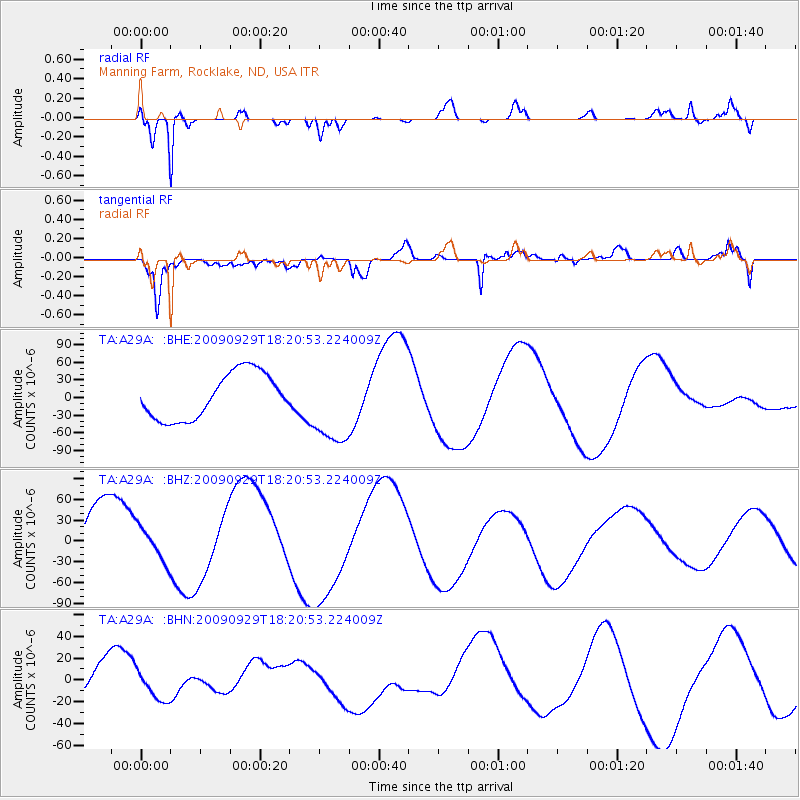
A29A Manning Farm, Rocklake, ND, USA - Earthquake Result Viewer
*The percent match for this event was below the threshold and hence no stack was calculated.
| Earthquake location: |
Samoa Islands Region |
| Earthquake latitude/longitude: |
-15.6/-172.0 |
| Earthquake time(UTC): |
2009/09/29 (272) 18:08:21 GMT |
| Earthquake Depth: |
10 km |
| Earthquake Magnitude: |
5.6 MB |
| Earthquake Catalog/Contributor: |
WHDF/NEIC |
|
| Network: |
TA USArray Transportable Network (new EarthScope stations) |
| Station: |
A29A Manning Farm, Rocklake, ND, USA |
| Lat/Lon: |
48.92 N/99.23 W |
| Elevation: |
480 m |
|
| Distance: |
90.7 deg |
| Az: |
39.055 deg |
| Baz: |
247.029 deg |
| Ray Param: |
$rayparam |
*The percent match for this event was below the threshold and hence was not used in the summary stack. |
|
| Radial Match: |
91.99873 % |
| Radial Bump: |
382 |
| Transverse Match: |
77.286545 % |
| Transverse Bump: |
400 |
| SOD ConfigId: |
2622 |
| Insert Time: |
2010-03-07 06:21:22.280 +0000 |
| GWidth: |
2.5 |
| Max Bumps: |
400 |
| Tol: |
0.001 |
|
Signal To Noise
| Channel | StoN | STA | LTA |
| TA:A29A: :BHZ:20090929T18:20:53.224009Z | 0.49292374 | 2.4135252E-5 | 4.896346E-5 |
| TA:A29A: :BHN:20090929T18:20:53.224009Z | 0.42479926 | 1.4958006E-5 | 3.5211942E-5 |
| TA:A29A: :BHE:20090929T18:20:53.224009Z | 1.7803373 | 6.9103306E-5 | 3.8814724E-5 |
| Arrivals |
| Ps | |
| PpPs | |
| PsPs/PpSs | |


