You are here: Home > Network List > TA - USArray Transportable Network (new EarthScope stations) Stations List
> Station A29A Manning Farm, Rocklake, ND, USA > Earthquake Result Viewer
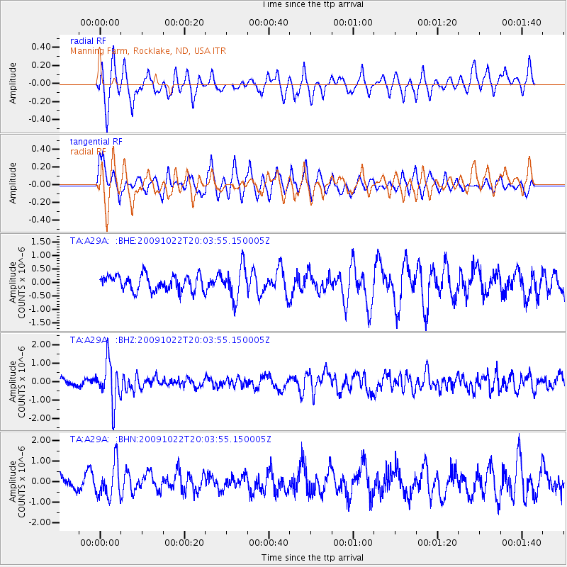
A29A Manning Farm, Rocklake, ND, USA - Earthquake Result Viewer
*The percent match for this event was below the threshold and hence no stack was calculated.
| Earthquake location: |
Hindu Kush Region, Afghanistan |
| Earthquake latitude/longitude: |
36.5/70.9 |
| Earthquake time(UTC): |
2009/10/22 (295) 19:51:27 GMT |
| Earthquake Depth: |
186 km |
| Earthquake Magnitude: |
6.1 MB, 6.2 MW, 6.1 MW |
| Earthquake Catalog/Contributor: |
WHDF/NEIC |
|
| Network: |
TA USArray Transportable Network (new EarthScope stations) |
| Station: |
A29A Manning Farm, Rocklake, ND, USA |
| Lat/Lon: |
48.92 N/99.23 W |
| Elevation: |
480 m |
|
| Distance: |
94.5 deg |
| Az: |
353.522 deg |
| Baz: |
7.92 deg |
| Ray Param: |
$rayparam |
*The percent match for this event was below the threshold and hence was not used in the summary stack. |
|
| Radial Match: |
60.775673 % |
| Radial Bump: |
364 |
| Transverse Match: |
54.28187 % |
| Transverse Bump: |
351 |
| SOD ConfigId: |
2622 |
| Insert Time: |
2010-03-07 06:21:30.613 +0000 |
| GWidth: |
2.5 |
| Max Bumps: |
400 |
| Tol: |
0.001 |
|
Signal To Noise
| Channel | StoN | STA | LTA |
| TA:A29A: :BHZ:20091022T20:03:55.150005Z | 5.3888593 | 1.1417851E-6 | 2.1187881E-7 |
| TA:A29A: :BHN:20091022T20:03:55.150005Z | 2.429598 | 8.425857E-7 | 3.4680045E-7 |
| TA:A29A: :BHE:20091022T20:03:55.150005Z | 2.1451898 | 6.0630316E-7 | 2.8263378E-7 |
| Arrivals |
| Ps | |
| PpPs | |
| PsPs/PpSs | |


