You are here: Home > Network List > TA - USArray Transportable Network (new EarthScope stations) Stations List
> Station F29A Eureka, SD, USA > Earthquake Result Viewer
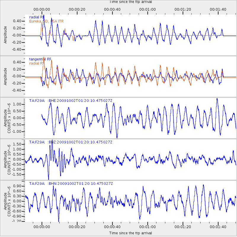
F29A Eureka, SD, USA - Earthquake Result Viewer
*The percent match for this event was below the threshold and hence no stack was calculated.
| Earthquake location: |
Tonga Islands |
| Earthquake latitude/longitude: |
-16.3/-173.5 |
| Earthquake time(UTC): |
2009/10/02 (275) 01:07:39 GMT |
| Earthquake Depth: |
8.0 km |
| Earthquake Magnitude: |
6.1 MB, 6.0 MS, 6.1 MW, 6.1 MW |
| Earthquake Catalog/Contributor: |
WHDF/NEIC |
|
| Network: |
TA USArray Transportable Network (new EarthScope stations) |
| Station: |
F29A Eureka, SD, USA |
| Lat/Lon: |
45.83 N/99.83 W |
| Elevation: |
575 m |
|
| Distance: |
90.6 deg |
| Az: |
42.136 deg |
| Baz: |
247.122 deg |
| Ray Param: |
$rayparam |
*The percent match for this event was below the threshold and hence was not used in the summary stack. |
|
| Radial Match: |
61.82888 % |
| Radial Bump: |
307 |
| Transverse Match: |
58.04547 % |
| Transverse Bump: |
353 |
| SOD ConfigId: |
2622 |
| Insert Time: |
2010-03-07 06:21:53.622 +0000 |
| GWidth: |
2.5 |
| Max Bumps: |
400 |
| Tol: |
0.001 |
|
Signal To Noise
| Channel | StoN | STA | LTA |
| TA:F29A: :BHZ:20091002T01:20:10.475027Z | 4.2381134 | 7.2297763E-7 | 1.7058949E-7 |
| TA:F29A: :BHN:20091002T01:20:10.475027Z | 0.57052827 | 3.0283755E-7 | 5.3080197E-7 |
| TA:F29A: :BHE:20091002T01:20:10.475027Z | 0.5198793 | 2.588906E-7 | 4.9798217E-7 |
| Arrivals |
| Ps | |
| PpPs | |
| PsPs/PpSs | |


