You are here: Home > Network List > TA - USArray Transportable Network (new EarthScope stations) Stations List
> Station F29A Eureka, SD, USA > Earthquake Result Viewer
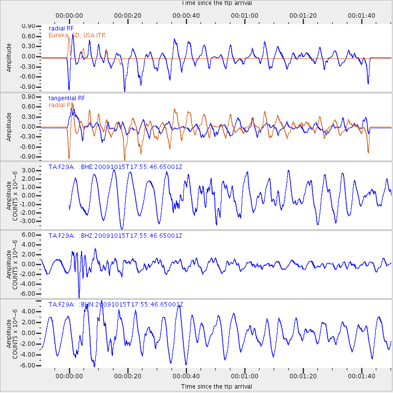
F29A Eureka, SD, USA - Earthquake Result Viewer
*The percent match for this event was below the threshold and hence no stack was calculated.
| Earthquake location: |
Galapagos Triple Junction Region |
| Earthquake latitude/longitude: |
3.3/-103.8 |
| Earthquake time(UTC): |
2009/10/15 (288) 17:48:21 GMT |
| Earthquake Depth: |
10 km |
| Earthquake Magnitude: |
5.9 MB, 5.7 MS, 6.0 MW, 6.0 MW |
| Earthquake Catalog/Contributor: |
WHDF/NEIC |
|
| Network: |
TA USArray Transportable Network (new EarthScope stations) |
| Station: |
F29A Eureka, SD, USA |
| Lat/Lon: |
45.83 N/99.83 W |
| Elevation: |
575 m |
|
| Distance: |
42.5 deg |
| Az: |
4.133 deg |
| Baz: |
185.907 deg |
| Ray Param: |
$rayparam |
*The percent match for this event was below the threshold and hence was not used in the summary stack. |
|
| Radial Match: |
54.14885 % |
| Radial Bump: |
400 |
| Transverse Match: |
76.60068 % |
| Transverse Bump: |
390 |
| SOD ConfigId: |
2622 |
| Insert Time: |
2010-03-07 06:21:58.384 +0000 |
| GWidth: |
2.5 |
| Max Bumps: |
400 |
| Tol: |
0.001 |
|
Signal To Noise
| Channel | StoN | STA | LTA |
| TA:F29A: :BHZ:20091015T17:55:46.65001Z | 2.009903 | 2.3136463E-6 | 1.1511235E-6 |
| TA:F29A: :BHN:20091015T17:55:46.65001Z | 1.6747438 | 2.6606638E-6 | 1.5886991E-6 |
| TA:F29A: :BHE:20091015T17:55:46.65001Z | 1.0065465 | 1.9260067E-6 | 1.91348E-6 |
| Arrivals |
| Ps | |
| PpPs | |
| PsPs/PpSs | |


