You are here: Home > Network List > CM - Red Sismologica Nacional de Columbia Stations List
> Station URI Uribia, Guajira, Columbia > Earthquake Result Viewer
URI Uribia, Guajira, Columbia - Earthquake Result Viewer
| Earthquake location: |
Near East Coast Of Kamchatka |
| Earthquake latitude/longitude: |
56.9/162.7 |
| Earthquake time(UTC): |
2017/03/29 (088) 04:09:24 GMT |
| Earthquake Depth: |
23 km |
| Earthquake Magnitude: |
6.6 Mww |
| Earthquake Catalog/Contributor: |
NEIC PDE/us |
|
| Network: |
CM Red Sismologica Nacional de Columbia |
| Station: |
URI Uribia, Guajira, Columbia |
| Lat/Lon: |
11.70 N/71.99 W |
| Elevation: |
68 m |
|
| Distance: |
98.1 deg |
| Az: |
53.88 deg |
| Baz: |
333.112 deg |
| Ray Param: |
0.039984815 |
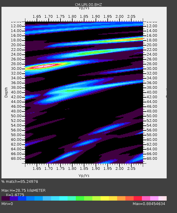
| Estimated Moho Depth: |
28.75 km |
| Estimated Crust Vp/Vs: |
1.68 |
| Assumed Crust Vp: |
5.738 km/s |
| Estimated Crust Vs: |
3.421 km/s |
| Estimated Crust Poisson's Ratio: |
0.22 |
|
| Radial Match: |
85.24976 % |
| Radial Bump: |
400 |
| Transverse Match: |
75.45657 % |
| Transverse Bump: |
400 |
| SOD ConfigId: |
2028011 |
| Insert Time: |
2017-04-12 04:12:08.037 +0000 |
| GWidth: |
2.5 |
| Max Bumps: |
400 |
| Tol: |
0.001 |
|

Signal To Noise
| Channel | StoN | STA | LTA |
| CM:URI:00:BHZ:20170329T04:22:28.019026Z | 11.776067 | 8.8847685E-7 | 7.544767E-8 |
| CM:URI:00:BHN:20170329T04:22:28.019026Z | 2.429607 | 1.7413322E-7 | 7.167135E-8 |
| CM:URI:00:BHE:20170329T04:22:28.019026Z | 0.8393973 | 7.8883645E-8 | 9.3976524E-8 |
| Arrivals |
| Ps | 3.4 SECOND |
| PpPs | 13 SECOND |
| PsPs/PpSs | 17 SECOND |


