You are here: Home > Network List > TA - USArray Transportable Network (new EarthScope stations) Stations List
> Station E30A Jud, ND, USA > Earthquake Result Viewer
E30A Jud, ND, USA - Earthquake Result Viewer
| Earthquake location: |
Near Coast Of Venezuela |
| Earthquake latitude/longitude: |
10.7/-67.9 |
| Earthquake time(UTC): |
2009/09/12 (255) 20:06:24 GMT |
| Earthquake Depth: |
10 km |
| Earthquake Magnitude: |
6.3 MB, 6.4 MS, 6.3 MW, 6.3 MW |
| Earthquake Catalog/Contributor: |
WHDF/NEIC |
|
| Network: |
TA USArray Transportable Network (new EarthScope stations) |
| Station: |
E30A Jud, ND, USA |
| Lat/Lon: |
46.50 N/98.91 W |
| Elevation: |
544 m |
|
| Distance: |
44.3 deg |
| Az: |
329.4 deg |
| Baz: |
133.591 deg |
| Ray Param: |
0.07198838 |
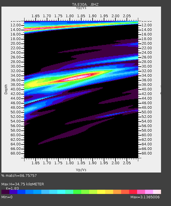
| Estimated Moho Depth: |
34.75 km |
| Estimated Crust Vp/Vs: |
1.83 |
| Assumed Crust Vp: |
6.53 km/s |
| Estimated Crust Vs: |
3.569 km/s |
| Estimated Crust Poisson's Ratio: |
0.29 |
|
| Radial Match: |
86.75757 % |
| Radial Bump: |
400 |
| Transverse Match: |
46.143604 % |
| Transverse Bump: |
400 |
| SOD ConfigId: |
2622 |
| Insert Time: |
2010-03-07 06:22:27.188 +0000 |
| GWidth: |
2.5 |
| Max Bumps: |
400 |
| Tol: |
0.001 |
|

Signal To Noise
| Channel | StoN | STA | LTA |
| TA:E30A: :BHZ:20090912T20:14:03.823992Z | 9.341047 | 2.0258624E-6 | 2.1687742E-7 |
| TA:E30A: :BHN:20090912T20:14:03.823992Z | 1.7972425 | 1.1219427E-6 | 6.242578E-7 |
| TA:E30A: :BHE:20090912T20:14:03.823992Z | 2.508444 | 8.9897395E-7 | 3.5837908E-7 |
| Arrivals |
| Ps | 4.7 SECOND |
| PpPs | 14 SECOND |
| PsPs/PpSs | 19 SECOND |


