You are here: Home > Network List > ET - CERI Southern Appalachian seismic Network Stations List
> Station CPCT Cooper Cave,TN > Earthquake Result Viewer
CPCT Cooper Cave,TN - Earthquake Result Viewer
| Earthquake location: |
Near East Coast Of Kamchatka |
| Earthquake latitude/longitude: |
56.9/162.7 |
| Earthquake time(UTC): |
2017/03/29 (088) 04:09:24 GMT |
| Earthquake Depth: |
23 km |
| Earthquake Magnitude: |
6.6 Mww |
| Earthquake Catalog/Contributor: |
NEIC PDE/us |
|
| Network: |
ET CERI Southern Appalachian seismic Network |
| Station: |
CPCT Cooper Cave,TN |
| Lat/Lon: |
35.45 N/84.52 W |
| Elevation: |
275 m |
|
| Distance: |
72.0 deg |
| Az: |
52.365 deg |
| Baz: |
327.866 deg |
| Ray Param: |
0.053955775 |
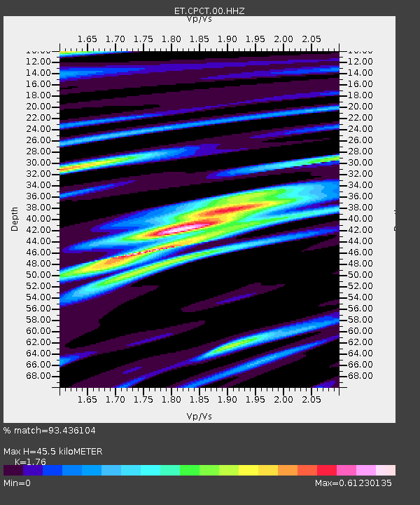
| Estimated Moho Depth: |
45.5 km |
| Estimated Crust Vp/Vs: |
1.76 |
| Assumed Crust Vp: |
6.35 km/s |
| Estimated Crust Vs: |
3.608 km/s |
| Estimated Crust Poisson's Ratio: |
0.26 |
|
| Radial Match: |
93.436104 % |
| Radial Bump: |
400 |
| Transverse Match: |
72.07361 % |
| Transverse Bump: |
400 |
| SOD ConfigId: |
2028011 |
| Insert Time: |
2017-04-12 04:12:53.430 +0000 |
| GWidth: |
2.5 |
| Max Bumps: |
400 |
| Tol: |
0.001 |
|

Signal To Noise
| Channel | StoN | STA | LTA |
| ET:CPCT:00:HHZ:20170329T04:20:15.21501Z | 20.97042 | 3.8644694E-6 | 1.8428192E-7 |
| ET:CPCT:00:HHN:20170329T04:20:15.21501Z | 8.473098 | 1.1779363E-6 | 1.3902073E-7 |
| ET:CPCT:00:HHE:20170329T04:20:15.21501Z | 9.222095 | 8.172489E-7 | 8.861858E-8 |
| Arrivals |
| Ps | 5.6 SECOND |
| PpPs | 19 SECOND |
| PsPs/PpSs | 25 SECOND |


