You are here: Home > Network List > TA - USArray Transportable Network (new EarthScope stations) Stations List
> Station C36M Paulatuk, NT, CAN > Earthquake Result Viewer
C36M Paulatuk, NT, CAN - Earthquake Result Viewer
| Earthquake location: |
Andreanof Islands, Aleutian Is. |
| Earthquake latitude/longitude: |
51.0/-178.2 |
| Earthquake time(UTC): |
2019/12/02 (336) 05:01:55 GMT |
| Earthquake Depth: |
35 km |
| Earthquake Magnitude: |
6.1 Mi |
| Earthquake Catalog/Contributor: |
NEIC PDE/at |
|
| Network: |
TA USArray Transportable Network (new EarthScope stations) |
| Station: |
C36M Paulatuk, NT, CAN |
| Lat/Lon: |
69.35 N/124.07 W |
| Elevation: |
10 m |
|
| Distance: |
31.1 deg |
| Az: |
33.82 deg |
| Baz: |
262.145 deg |
| Ray Param: |
0.0791216 |
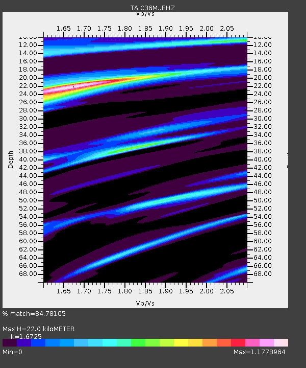
| Estimated Moho Depth: |
22.0 km |
| Estimated Crust Vp/Vs: |
1.67 |
| Assumed Crust Vp: |
6.459 km/s |
| Estimated Crust Vs: |
3.862 km/s |
| Estimated Crust Poisson's Ratio: |
0.22 |
|
| Radial Match: |
84.78105 % |
| Radial Bump: |
279 |
| Transverse Match: |
71.19332 % |
| Transverse Bump: |
378 |
| SOD ConfigId: |
19951751 |
| Insert Time: |
2019-12-16 05:15:33.709 +0000 |
| GWidth: |
2.5 |
| Max Bumps: |
400 |
| Tol: |
0.001 |
|

Signal To Noise
| Channel | StoN | STA | LTA |
| TA:C36M: :BHZ:20191202T05:07:39.899994Z | 3.8425076 | 9.93822E-7 | 2.5863895E-7 |
| TA:C36M: :BHN:20191202T05:07:39.899994Z | 0.4148175 | 1.4379563E-7 | 3.466479E-7 |
| TA:C36M: :BHE:20191202T05:07:39.899994Z | 1.5782765 | 4.8150116E-7 | 3.0508033E-7 |
| Arrivals |
| Ps | 2.5 SECOND |
| PpPs | 8.4 SECOND |
| PsPs/PpSs | 11 SECOND |


