You are here: Home > Network List > TA - USArray Transportable Network (new EarthScope stations) Stations List
> Station T24B San Luis, CO, USA > Earthquake Result Viewer
T24B San Luis, CO, USA - Earthquake Result Viewer
| Earthquake location: |
Samoa Islands Region |
| Earthquake latitude/longitude: |
-15.5/-172.1 |
| Earthquake time(UTC): |
2009/09/29 (272) 17:48:10 GMT |
| Earthquake Depth: |
18 km |
| Earthquake Magnitude: |
7.1 MB, 8.1 MS, 8.1 MW, 8.0 MW |
| Earthquake Catalog/Contributor: |
WHDF/NEIC |
|
| Network: |
TA USArray Transportable Network (new EarthScope stations) |
| Station: |
T24B San Luis, CO, USA |
| Lat/Lon: |
37.06 N/105.38 W |
| Elevation: |
2625 m |
|
| Distance: |
81.6 deg |
| Az: |
47.96 deg |
| Baz: |
243.527 deg |
| Ray Param: |
0.04743985 |
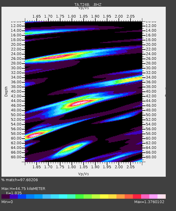
| Estimated Moho Depth: |
44.75 km |
| Estimated Crust Vp/Vs: |
1.84 |
| Assumed Crust Vp: |
6.316 km/s |
| Estimated Crust Vs: |
3.442 km/s |
| Estimated Crust Poisson's Ratio: |
0.29 |
|
| Radial Match: |
97.68206 % |
| Radial Bump: |
400 |
| Transverse Match: |
94.27002 % |
| Transverse Bump: |
400 |
| SOD ConfigId: |
2622 |
| Insert Time: |
2010-03-07 06:22:45.588 +0000 |
| GWidth: |
2.5 |
| Max Bumps: |
400 |
| Tol: |
0.001 |
|

Signal To Noise
| Channel | StoN | STA | LTA |
| TA:T24B: :BHZ:20090929T17:59:56.424021Z | 10.942241 | 2.2458182E-6 | 2.05243E-7 |
| TA:T24B: :BHN:20090929T17:59:56.424021Z | 1.5721817 | 3.0089302E-7 | 1.9138565E-7 |
| TA:T24B: :BHE:20090929T17:59:56.424021Z | 2.1105099 | 4.4489E-7 | 2.107974E-7 |
| Arrivals |
| Ps | 6.1 SECOND |
| PpPs | 20 SECOND |
| PsPs/PpSs | 26 SECOND |


