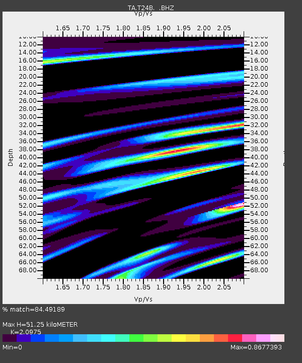
T24B San Luis, CO, USA - Earthquake Result Viewer

Earthquake location: Fox Islands, Aleutian Islands
Earthquake latitude/longitude: 52.6/-167.1
Earthquake time(UTC): 2009/10/13 (286) 20:21:53 GMT
Earthquake Depth: 14 km
Earthquake Magnitude: 5.9 MB, 6.4 MS, 6.4 MW, 6.4 MW
Earthquake Catalog/Contributor: WHDF/NEIC
Network: TA USArray Transportable Network (new EarthScope stations)
Station: T24B San Luis, CO, USA
Lat/Lon: 37.06 N/105.38 W
Elevation: 2625 m
Distance: 45.0 deg
Az: 84.663 deg
Baz: 310.612 deg
Ray Param: 0.07152893
Estimated Moho Depth: 51.25 km
Estimated Crust Vp/Vs: 2.10
Assumed Crust Vp: 6.316 km/s
Estimated Crust Vs: 3.011 km/s
Estimated Crust Poisson's Ratio: 0.35
Radial Match: 84.49189 %
Radial Bump: 400
Transverse Match: 71.58143 %
Transverse Bump: 400
SOD ConfigId: 2622
Insert Time: 2010-03-07 06:22:47.128 +0000
GWidth: 2.5
Max Bumps: 400
Tol: 0.001

Signal To Noise

ChannelStoNSTALTA
TA:T24B: :BHZ:20091013T20:29:37.450Z1.49751513.454082E-72.3065424E-7
TA:T24B: :BHN:20091013T20:29:37.450Z1.3161474.936769E-73.7509253E-7
TA:T24B: :BHE:20091013T20:29:37.450Z2.24953375.4452505E-72.4206128E-7
Arrivals
Ps9.4 SECOND
PpPs24 SECOND
PsPs/PpSs33 SECOND