You are here: Home > Network List > UW - Pacific Northwest Regional Seismic Network Stations List
> Station UMAT Pilot Rock, OR, USA > Earthquake Result Viewer
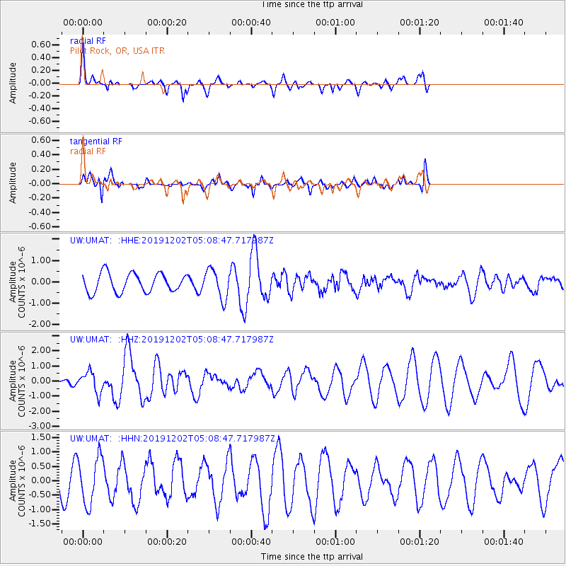
UMAT Pilot Rock, OR, USA - Earthquake Result Viewer
*The percent match for this event was below the threshold and hence no stack was calculated.
| Earthquake location: |
Andreanof Islands, Aleutian Is. |
| Earthquake latitude/longitude: |
51.0/-178.2 |
| Earthquake time(UTC): |
2019/12/02 (336) 05:01:55 GMT |
| Earthquake Depth: |
35 km |
| Earthquake Magnitude: |
6.1 Mi |
| Earthquake Catalog/Contributor: |
NEIC PDE/at |
|
| Network: |
UW Pacific Northwest Regional Seismic Network |
| Station: |
UMAT Pilot Rock, OR, USA |
| Lat/Lon: |
45.29 N/118.96 W |
| Elevation: |
1318 m |
|
| Distance: |
39.0 deg |
| Az: |
74.566 deg |
| Baz: |
300.429 deg |
| Ray Param: |
$rayparam |
*The percent match for this event was below the threshold and hence was not used in the summary stack. |
|
| Radial Match: |
67.26946 % |
| Radial Bump: |
348 |
| Transverse Match: |
75.17159 % |
| Transverse Bump: |
377 |
| SOD ConfigId: |
19951751 |
| Insert Time: |
2019-12-16 05:16:55.696 +0000 |
| GWidth: |
2.5 |
| Max Bumps: |
400 |
| Tol: |
0.001 |
|
Signal To Noise
| Channel | StoN | STA | LTA |
| UW:UMAT: :HHZ:20191202T05:08:47.717987Z | 1.6146494 | 7.077456E-7 | 4.3832773E-7 |
| UW:UMAT: :HHN:20191202T05:08:47.717987Z | 0.97311413 | 8.2150774E-7 | 8.44205E-7 |
| UW:UMAT: :HHE:20191202T05:08:47.717987Z | 1.6111456 | 7.01981E-7 | 4.3570302E-7 |
| Arrivals |
| Ps | |
| PpPs | |
| PsPs/PpSs | |


