You are here: Home > Network List > TA - USArray Transportable Network (new EarthScope stations) Stations List
> Station T24B San Luis, CO, USA > Earthquake Result Viewer
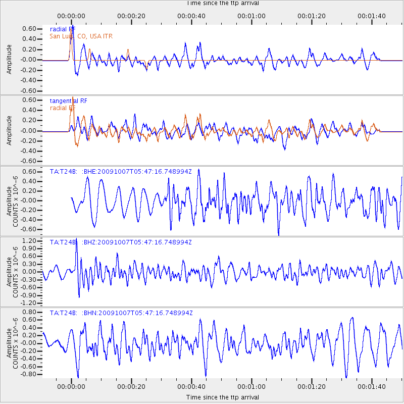
T24B San Luis, CO, USA - Earthquake Result Viewer
*The percent match for this event was below the threshold and hence no stack was calculated.
| Earthquake location: |
Rat Islands, Aleutian Islands |
| Earthquake latitude/longitude: |
52.2/178.1 |
| Earthquake time(UTC): |
2009/10/07 (280) 05:38:37 GMT |
| Earthquake Depth: |
138 km |
| Earthquake Magnitude: |
5.6 MB, 5.6 MW, 5.6 MW |
| Earthquake Catalog/Contributor: |
WHDF/NEIC |
|
| Network: |
TA USArray Transportable Network (new EarthScope stations) |
| Station: |
T24B San Luis, CO, USA |
| Lat/Lon: |
37.06 N/105.38 W |
| Elevation: |
2625 m |
|
| Distance: |
54.0 deg |
| Az: |
73.985 deg |
| Baz: |
312.246 deg |
| Ray Param: |
$rayparam |
*The percent match for this event was below the threshold and hence was not used in the summary stack. |
|
| Radial Match: |
59.859043 % |
| Radial Bump: |
395 |
| Transverse Match: |
57.914066 % |
| Transverse Bump: |
400 |
| SOD ConfigId: |
2622 |
| Insert Time: |
2010-03-07 06:22:59.149 +0000 |
| GWidth: |
2.5 |
| Max Bumps: |
400 |
| Tol: |
0.001 |
|
Signal To Noise
| Channel | StoN | STA | LTA |
| TA:T24B: :BHZ:20091007T05:47:16.748994Z | 3.290347 | 4.7376633E-7 | 1.4398674E-7 |
| TA:T24B: :BHN:20091007T05:47:16.748994Z | 1.4030286 | 4.059995E-7 | 2.8937365E-7 |
| TA:T24B: :BHE:20091007T05:47:16.748994Z | 0.90810364 | 2.3083346E-7 | 2.5419286E-7 |
| Arrivals |
| Ps | |
| PpPs | |
| PsPs/PpSs | |


