You are here: Home > Network List > TA - USArray Transportable Network (new EarthScope stations) Stations List
> Station T24B San Luis, CO, USA > Earthquake Result Viewer
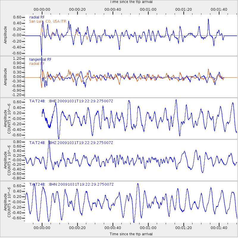
T24B San Luis, CO, USA - Earthquake Result Viewer
*The percent match for this event was below the threshold and hence no stack was calculated.
| Earthquake location: |
Santa Cruz Islands |
| Earthquake latitude/longitude: |
-11.4/166.4 |
| Earthquake time(UTC): |
2009/10/31 (304) 19:09:51 GMT |
| Earthquake Depth: |
134 km |
| Earthquake Magnitude: |
5.9 MB, 5.9 MW, 5.9 MW |
| Earthquake Catalog/Contributor: |
WHDF/NEIC |
|
| Network: |
TA USArray Transportable Network (new EarthScope stations) |
| Station: |
T24B San Luis, CO, USA |
| Lat/Lon: |
37.06 N/105.38 W |
| Elevation: |
2625 m |
|
| Distance: |
95.4 deg |
| Az: |
53.424 deg |
| Baz: |
259.887 deg |
| Ray Param: |
$rayparam |
*The percent match for this event was below the threshold and hence was not used in the summary stack. |
|
| Radial Match: |
56.833538 % |
| Radial Bump: |
400 |
| Transverse Match: |
56.581917 % |
| Transverse Bump: |
400 |
| SOD ConfigId: |
2622 |
| Insert Time: |
2010-03-07 06:23:06.615 +0000 |
| GWidth: |
2.5 |
| Max Bumps: |
400 |
| Tol: |
0.001 |
|
Signal To Noise
| Channel | StoN | STA | LTA |
| TA:T24B: :BHZ:20091031T19:22:29.275007Z | 2.187166 | 3.4956958E-7 | 1.5982764E-7 |
| TA:T24B: :BHN:20091031T19:22:29.275007Z | 0.98465794 | 4.3901565E-7 | 4.45856E-7 |
| TA:T24B: :BHE:20091031T19:22:29.275007Z | 1.0645596 | 2.5410023E-7 | 2.386905E-7 |
| Arrivals |
| Ps | |
| PpPs | |
| PsPs/PpSs | |


