You are here: Home > Network List > GS - US Geological Survey Networks Stations List
> Station KAN06 West of Argonia, Argonia, KS, USA > Earthquake Result Viewer
KAN06 West of Argonia, Argonia, KS, USA - Earthquake Result Viewer
| Earthquake location: |
Near East Coast Of Kamchatka |
| Earthquake latitude/longitude: |
56.9/162.7 |
| Earthquake time(UTC): |
2017/03/29 (088) 04:09:24 GMT |
| Earthquake Depth: |
23 km |
| Earthquake Magnitude: |
6.6 Mww |
| Earthquake Catalog/Contributor: |
NEIC PDE/us |
|
| Network: |
GS US Geological Survey Networks |
| Station: |
KAN06 West of Argonia, Argonia, KS, USA |
| Lat/Lon: |
37.25 N/97.86 W |
| Elevation: |
393 m |
|
| Distance: |
64.4 deg |
| Az: |
60.822 deg |
| Baz: |
323.129 deg |
| Ray Param: |
0.05893369 |
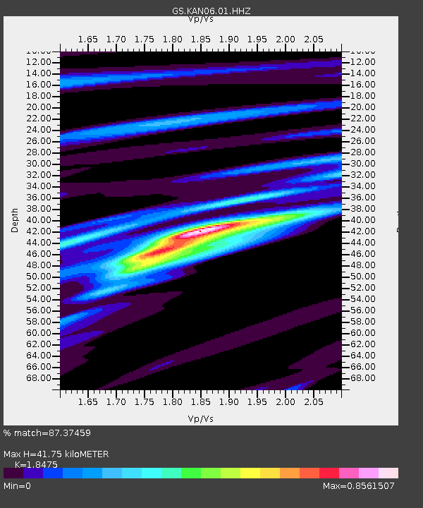
| Estimated Moho Depth: |
41.75 km |
| Estimated Crust Vp/Vs: |
1.85 |
| Assumed Crust Vp: |
6.483 km/s |
| Estimated Crust Vs: |
3.509 km/s |
| Estimated Crust Poisson's Ratio: |
0.29 |
|
| Radial Match: |
87.37459 % |
| Radial Bump: |
400 |
| Transverse Match: |
73.16449 % |
| Transverse Bump: |
400 |
| SOD ConfigId: |
2028011 |
| Insert Time: |
2017-04-12 04:13:36.680 +0000 |
| GWidth: |
2.5 |
| Max Bumps: |
400 |
| Tol: |
0.001 |
|

Signal To Noise
| Channel | StoN | STA | LTA |
| GS:KAN06:01:HHZ:20170329T04:19:27.790022Z | 14.436432 | 3.050817E-6 | 2.1132765E-7 |
| GS:KAN06:01:HHN:20170329T04:19:27.790022Z | 3.5709019 | 1.7330652E-6 | 4.8532985E-7 |
| GS:KAN06:01:HHE:20170329T04:19:27.790022Z | 1.9373106 | 9.1556035E-7 | 4.7259348E-7 |
| Arrivals |
| Ps | 5.7 SECOND |
| PpPs | 18 SECOND |
| PsPs/PpSs | 23 SECOND |


