You are here: Home > Network List > TA - USArray Transportable Network (new EarthScope stations) Stations List
> Station B29A Wagenman Farm, Cando, ND, USA > Earthquake Result Viewer
B29A Wagenman Farm, Cando, ND, USA - Earthquake Result Viewer
| Earthquake location: |
Fox Islands, Aleutian Islands |
| Earthquake latitude/longitude: |
52.8/-167.0 |
| Earthquake time(UTC): |
2009/10/13 (286) 05:37:23 GMT |
| Earthquake Depth: |
24 km |
| Earthquake Magnitude: |
6.0 MB, 6.1 MS, 6.5 MW, 6.5 MW |
| Earthquake Catalog/Contributor: |
WHDF/NEIC |
|
| Network: |
TA USArray Transportable Network (new EarthScope stations) |
| Station: |
B29A Wagenman Farm, Cando, ND, USA |
| Lat/Lon: |
48.46 N/99.35 W |
| Elevation: |
460 m |
|
| Distance: |
41.7 deg |
| Az: |
67.688 deg |
| Baz: |
302.344 deg |
| Ray Param: |
0.073580354 |
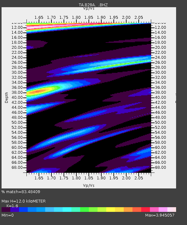
| Estimated Moho Depth: |
12.0 km |
| Estimated Crust Vp/Vs: |
1.60 |
| Assumed Crust Vp: |
6.53 km/s |
| Estimated Crust Vs: |
4.082 km/s |
| Estimated Crust Poisson's Ratio: |
0.18 |
|
| Radial Match: |
83.48409 % |
| Radial Bump: |
400 |
| Transverse Match: |
61.008244 % |
| Transverse Bump: |
400 |
| SOD ConfigId: |
2622 |
| Insert Time: |
2010-03-07 06:23:15.664 +0000 |
| GWidth: |
2.5 |
| Max Bumps: |
400 |
| Tol: |
0.001 |
|

Signal To Noise
| Channel | StoN | STA | LTA |
| TA:B29A: :BHZ:20091013T05:44:39.799009Z | 2.6122377 | 8.017536E-7 | 3.0692212E-7 |
| TA:B29A: :BHN:20091013T05:44:39.799009Z | 0.9608989 | 6.932348E-7 | 7.214441E-7 |
| TA:B29A: :BHE:20091013T05:44:39.799009Z | 1.8992901 | 1.5094765E-6 | 7.947583E-7 |
| Arrivals |
| Ps | 1.2 SECOND |
| PpPs | 4.4 SECOND |
| PsPs/PpSs | 5.6 SECOND |


