You are here: Home > Network List > GS - US Geological Survey Networks Stations List
> Station OK051 E0350 and S34600 Roads, Ralston, OK > Earthquake Result Viewer
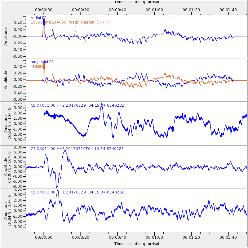
OK051 E0350 and S34600 Roads, Ralston, OK - Earthquake Result Viewer
*The percent match for this event was below the threshold and hence no stack was calculated.
| Earthquake location: |
Near East Coast Of Kamchatka |
| Earthquake latitude/longitude: |
56.9/162.7 |
| Earthquake time(UTC): |
2017/03/29 (088) 04:09:24 GMT |
| Earthquake Depth: |
23 km |
| Earthquake Magnitude: |
6.6 Mww |
| Earthquake Catalog/Contributor: |
NEIC PDE/us |
|
| Network: |
GS US Geological Survey Networks |
| Station: |
OK051 E0350 and S34600 Roads, Ralston, OK |
| Lat/Lon: |
36.51 N/96.84 W |
| Elevation: |
263 m |
|
| Distance: |
65.5 deg |
| Az: |
60.584 deg |
| Baz: |
323.639 deg |
| Ray Param: |
$rayparam |
*The percent match for this event was below the threshold and hence was not used in the summary stack. |
|
| Radial Match: |
74.494865 % |
| Radial Bump: |
400 |
| Transverse Match: |
37.308918 % |
| Transverse Bump: |
400 |
| SOD ConfigId: |
2028011 |
| Insert Time: |
2017-04-12 04:14:02.359 +0000 |
| GWidth: |
2.5 |
| Max Bumps: |
400 |
| Tol: |
0.001 |
|
Signal To Noise
| Channel | StoN | STA | LTA |
| GS:OK051:00:HHZ:20170329T04:19:34.834028Z | 16.77016 | 2.756014E-6 | 1.6434035E-7 |
| GS:OK051:00:HH1:20170329T04:19:34.834028Z | 0.78458333 | 1.1094257E-6 | 1.4140318E-6 |
| GS:OK051:00:HH2:20170329T04:19:34.834028Z | 1.1671464 | 1.6580145E-6 | 1.4205712E-6 |
| Arrivals |
| Ps | |
| PpPs | |
| PsPs/PpSs | |


