You are here: Home > Network List > TA - USArray Transportable Network (new EarthScope stations) Stations List
> Station L30A Spencer Herefords Ranch, Brewster, NE, USA > Earthquake Result Viewer
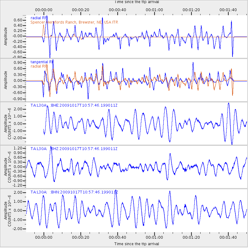
L30A Spencer Herefords Ranch, Brewster, NE, USA - Earthquake Result Viewer
*The percent match for this event was below the threshold and hence no stack was calculated.
| Earthquake location: |
Samoa Islands Region |
| Earthquake latitude/longitude: |
-16.4/-172.0 |
| Earthquake time(UTC): |
2009/10/17 (290) 10:45:26 GMT |
| Earthquake Depth: |
10 km |
| Earthquake Magnitude: |
5.7 MB, 5.3 MS, 5.7 MW, 5.7 MW |
| Earthquake Catalog/Contributor: |
WHDF/NEIC |
|
| Network: |
TA USArray Transportable Network (new EarthScope stations) |
| Station: |
L30A Spencer Herefords Ranch, Brewster, NE, USA |
| Lat/Lon: |
41.95 N/99.72 W |
| Elevation: |
782 m |
|
| Distance: |
88.2 deg |
| Az: |
45.306 deg |
| Baz: |
246.183 deg |
| Ray Param: |
$rayparam |
*The percent match for this event was below the threshold and hence was not used in the summary stack. |
|
| Radial Match: |
58.88041 % |
| Radial Bump: |
400 |
| Transverse Match: |
63.158005 % |
| Transverse Bump: |
379 |
| SOD ConfigId: |
2622 |
| Insert Time: |
2010-03-07 06:23:38.592 +0000 |
| GWidth: |
2.5 |
| Max Bumps: |
400 |
| Tol: |
0.001 |
|
Signal To Noise
| Channel | StoN | STA | LTA |
| TA:L30A: :BHZ:20091017T10:57:46.199011Z | 2.450152 | 6.162791E-7 | 2.515269E-7 |
| TA:L30A: :BHN:20091017T10:57:46.199011Z | 1.0807455 | 1.0621119E-6 | 9.827587E-7 |
| TA:L30A: :BHE:20091017T10:57:46.199011Z | 0.9670657 | 8.357863E-7 | 8.642498E-7 |
| Arrivals |
| Ps | |
| PpPs | |
| PsPs/PpSs | |


