You are here: Home > Network List > TA - USArray Transportable Network (new EarthScope stations) Stations List
> Station L30A Spencer Herefords Ranch, Brewster, NE, USA > Earthquake Result Viewer
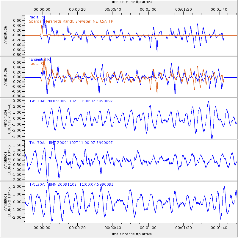
L30A Spencer Herefords Ranch, Brewster, NE, USA - Earthquake Result Viewer
*The percent match for this event was below the threshold and hence no stack was calculated.
| Earthquake location: |
South Of Tonga Islands |
| Earthquake latitude/longitude: |
-24.1/-175.2 |
| Earthquake time(UTC): |
2009/11/02 (306) 10:47:13 GMT |
| Earthquake Depth: |
9.0 km |
| Earthquake Magnitude: |
6.1 MB, 6.1 MS, 6.2 MW, 6.1 MW |
| Earthquake Catalog/Contributor: |
WHDF/NEIC |
|
| Network: |
TA USArray Transportable Network (new EarthScope stations) |
| Station: |
L30A Spencer Herefords Ranch, Brewster, NE, USA |
| Lat/Lon: |
41.95 N/99.72 W |
| Elevation: |
782 m |
|
| Distance: |
95.7 deg |
| Az: |
46.523 deg |
| Baz: |
242.725 deg |
| Ray Param: |
$rayparam |
*The percent match for this event was below the threshold and hence was not used in the summary stack. |
|
| Radial Match: |
63.817104 % |
| Radial Bump: |
370 |
| Transverse Match: |
66.59004 % |
| Transverse Bump: |
344 |
| SOD ConfigId: |
2622 |
| Insert Time: |
2010-03-07 06:23:41.621 +0000 |
| GWidth: |
2.5 |
| Max Bumps: |
400 |
| Tol: |
0.001 |
|
Signal To Noise
| Channel | StoN | STA | LTA |
| TA:L30A: :BHZ:20091102T11:00:07.599009Z | 2.689118 | 9.925263E-7 | 3.6908995E-7 |
| TA:L30A: :BHN:20091102T11:00:07.599009Z | 2.2659695 | 1.4107201E-6 | 6.22568E-7 |
| TA:L30A: :BHE:20091102T11:00:07.599009Z | 0.7288654 | 7.4336106E-7 | 1.0198879E-6 |
| Arrivals |
| Ps | |
| PpPs | |
| PsPs/PpSs | |


