You are here: Home > Network List > TS - TERRAscope (Southern California Seismic Network) Stations List
> Station PAS Pasadena, California, USA > Earthquake Result Viewer
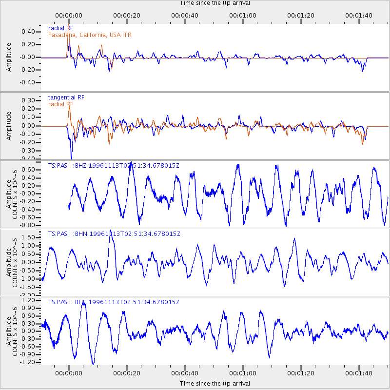
PAS Pasadena, California, USA - Earthquake Result Viewer
*The percent match for this event was below the threshold and hence no stack was calculated.
| Earthquake location: |
Near Coast Of Peru |
| Earthquake latitude/longitude: |
-14.8/-75.7 |
| Earthquake time(UTC): |
1996/11/13 (318) 02:41:39 GMT |
| Earthquake Depth: |
33 km |
| Earthquake Magnitude: |
5.6 MB, 5.8 MS, 6.0 UNKNOWN, 6.0 MW |
| Earthquake Catalog/Contributor: |
WHDF/NEIC |
|
| Network: |
TS TERRAscope (Southern California Seismic Network) |
| Station: |
PAS Pasadena, California, USA |
| Lat/Lon: |
34.15 N/118.17 W |
| Elevation: |
295 m |
|
| Distance: |
63.3 deg |
| Az: |
321.178 deg |
| Baz: |
133.03 deg |
| Ray Param: |
$rayparam |
*The percent match for this event was below the threshold and hence was not used in the summary stack. |
|
| Radial Match: |
66.639206 % |
| Radial Bump: |
400 |
| Transverse Match: |
60.242893 % |
| Transverse Bump: |
351 |
| SOD ConfigId: |
4480 |
| Insert Time: |
2010-02-26 14:37:38.395 +0000 |
| GWidth: |
2.5 |
| Max Bumps: |
400 |
| Tol: |
0.001 |
|
Signal To Noise
| Channel | StoN | STA | LTA |
| TS:PAS: :BHN:19961113T02:51:34.678015Z | 0.84604424 | 4.185784E-7 | 4.947476E-7 |
| TS:PAS: :BHE:19961113T02:51:34.678015Z | 1.5170606 | 6.713214E-7 | 4.4251453E-7 |
| TS:PAS: :BHZ:19961113T02:51:34.678015Z | 0.3952462 | 1.3245949E-7 | 3.351316E-7 |
| Arrivals |
| Ps | |
| PpPs | |
| PsPs/PpSs | |


