You are here: Home > Network List > TA - USArray Transportable Network (new EarthScope stations) Stations List
> Station N32A Stulken Farm, Doniphan, NE, USA > Earthquake Result Viewer
N32A Stulken Farm, Doniphan, NE, USA - Earthquake Result Viewer
| Earthquake location: |
East Of Severnaya Zemlya |
| Earthquake latitude/longitude: |
81.6/119.5 |
| Earthquake time(UTC): |
2009/10/07 (280) 20:52:13 GMT |
| Earthquake Depth: |
8.0 km |
| Earthquake Magnitude: |
5.7 MB, 5.1 MS, 5.8 MW, 5.8 MW |
| Earthquake Catalog/Contributor: |
WHDF/NEIC |
|
| Network: |
TA USArray Transportable Network (new EarthScope stations) |
| Station: |
N32A Stulken Farm, Doniphan, NE, USA |
| Lat/Lon: |
40.76 N/98.30 W |
| Elevation: |
587 m |
|
| Distance: |
56.3 deg |
| Az: |
34.05 deg |
| Baz: |
353.757 deg |
| Ray Param: |
0.0642344 |
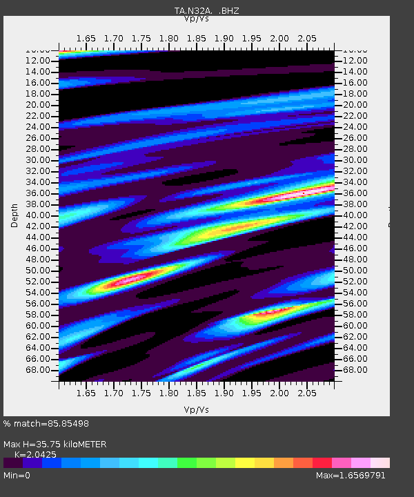
| Estimated Moho Depth: |
35.75 km |
| Estimated Crust Vp/Vs: |
2.04 |
| Assumed Crust Vp: |
6.53 km/s |
| Estimated Crust Vs: |
3.197 km/s |
| Estimated Crust Poisson's Ratio: |
0.34 |
|
| Radial Match: |
85.85498 % |
| Radial Bump: |
400 |
| Transverse Match: |
74.54373 % |
| Transverse Bump: |
400 |
| SOD ConfigId: |
2622 |
| Insert Time: |
2010-03-07 06:23:52.052 +0000 |
| GWidth: |
2.5 |
| Max Bumps: |
400 |
| Tol: |
0.001 |
|

Signal To Noise
| Channel | StoN | STA | LTA |
| TA:N32A: :BHZ:20091007T21:01:23.074016Z | 3.7840595 | 7.968317E-7 | 2.1057589E-7 |
| TA:N32A: :BHN:20091007T21:01:23.074016Z | 2.1392672 | 7.8852383E-7 | 3.685953E-7 |
| TA:N32A: :BHE:20091007T21:01:23.074016Z | 1.2835193 | 3.9102832E-7 | 3.0465324E-7 |
| Arrivals |
| Ps | 6.0 SECOND |
| PpPs | 16 SECOND |
| PsPs/PpSs | 22 SECOND |


