You are here: Home > Network List > IU - Global Seismograph Network (GSN - IRIS/USGS) Stations List
> Station CTAO Charters Towers, Australia > Earthquake Result Viewer
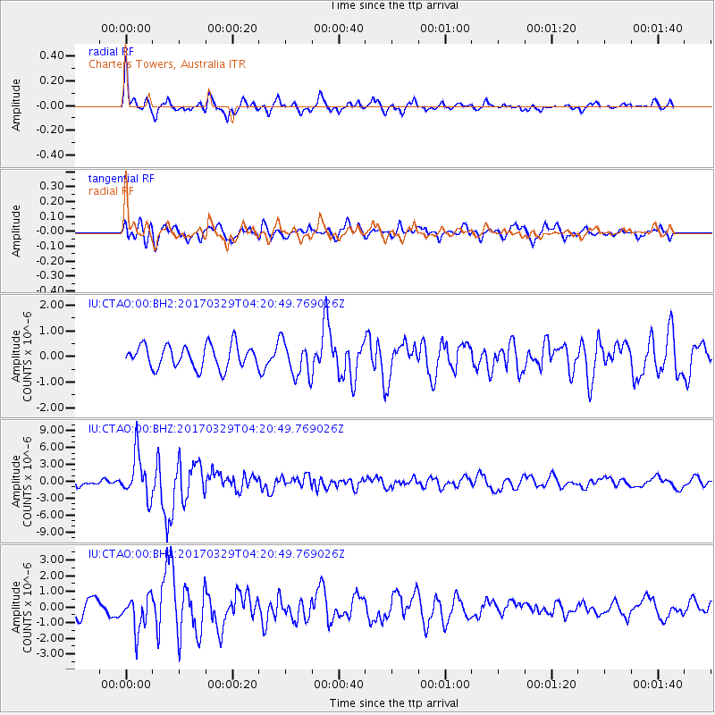
CTAO Charters Towers, Australia - Earthquake Result Viewer
*The percent match for this event was below the threshold and hence no stack was calculated.
| Earthquake location: |
Near East Coast Of Kamchatka |
| Earthquake latitude/longitude: |
56.9/162.7 |
| Earthquake time(UTC): |
2017/03/29 (088) 04:09:24 GMT |
| Earthquake Depth: |
23 km |
| Earthquake Magnitude: |
6.6 Mww |
| Earthquake Catalog/Contributor: |
NEIC PDE/us |
|
| Network: |
IU Global Seismograph Network (GSN - IRIS/USGS) |
| Station: |
CTAO Charters Towers, Australia |
| Lat/Lon: |
20.09 S/146.25 E |
| Elevation: |
357 m |
|
| Distance: |
78.0 deg |
| Az: |
195.821 deg |
| Baz: |
9.153 deg |
| Ray Param: |
$rayparam |
*The percent match for this event was below the threshold and hence was not used in the summary stack. |
|
| Radial Match: |
76.958405 % |
| Radial Bump: |
400 |
| Transverse Match: |
65.638145 % |
| Transverse Bump: |
400 |
| SOD ConfigId: |
2028011 |
| Insert Time: |
2017-04-12 04:14:41.703 +0000 |
| GWidth: |
2.5 |
| Max Bumps: |
400 |
| Tol: |
0.001 |
|
Signal To Noise
| Channel | StoN | STA | LTA |
| IU:CTAO:00:BHZ:20170329T04:20:49.769026Z | 7.9587994 | 3.905389E-6 | 4.9070076E-7 |
| IU:CTAO:00:BH1:20170329T04:20:49.769026Z | 2.1187909 | 1.0917138E-6 | 5.152532E-7 |
| IU:CTAO:00:BH2:20170329T04:20:49.769026Z | 1.5401925 | 6.8491477E-7 | 4.4469425E-7 |
| Arrivals |
| Ps | |
| PpPs | |
| PsPs/PpSs | |


