You are here: Home > Network List > TA - USArray Transportable Network (new EarthScope stations) Stations List
> Station F30A Leola, SD, USA > Earthquake Result Viewer
F30A Leola, SD, USA - Earthquake Result Viewer
| Earthquake location: |
Near Coast Of Venezuela |
| Earthquake latitude/longitude: |
10.7/-67.9 |
| Earthquake time(UTC): |
2009/09/12 (255) 20:06:24 GMT |
| Earthquake Depth: |
10 km |
| Earthquake Magnitude: |
6.3 MB, 6.4 MS, 6.3 MW, 6.3 MW |
| Earthquake Catalog/Contributor: |
WHDF/NEIC |
|
| Network: |
TA USArray Transportable Network (new EarthScope stations) |
| Station: |
F30A Leola, SD, USA |
| Lat/Lon: |
45.84 N/99.03 W |
| Elevation: |
601 m |
|
| Distance: |
43.9 deg |
| Az: |
328.624 deg |
| Baz: |
132.951 deg |
| Ray Param: |
0.07223662 |
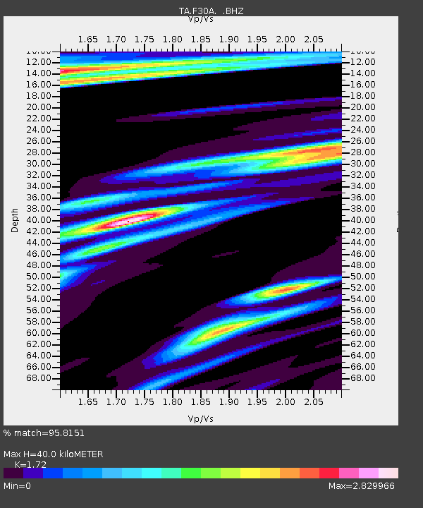
| Estimated Moho Depth: |
40.0 km |
| Estimated Crust Vp/Vs: |
1.72 |
| Assumed Crust Vp: |
6.53 km/s |
| Estimated Crust Vs: |
3.797 km/s |
| Estimated Crust Poisson's Ratio: |
0.24 |
|
| Radial Match: |
95.8151 % |
| Radial Bump: |
264 |
| Transverse Match: |
86.809906 % |
| Transverse Bump: |
398 |
| SOD ConfigId: |
2622 |
| Insert Time: |
2010-03-07 06:23:58.199 +0000 |
| GWidth: |
2.5 |
| Max Bumps: |
400 |
| Tol: |
0.001 |
|

Signal To Noise
| Channel | StoN | STA | LTA |
| TA:F30A: :BHZ:20090912T20:14:00.62401Z | 20.102146 | 2.1354615E-6 | 1.06230516E-7 |
| TA:F30A: :BHN:20090912T20:14:00.62401Z | 1.970922 | 1.0600003E-6 | 5.378195E-7 |
| TA:F30A: :BHE:20090912T20:14:00.62401Z | 2.0452888 | 9.822023E-7 | 4.8022673E-7 |
| Arrivals |
| Ps | 4.7 SECOND |
| PpPs | 16 SECOND |
| PsPs/PpSs | 20 SECOND |


