You are here: Home > Network List > IU - Global Seismograph Network (GSN - IRIS/USGS) Stations List
> Station RSSD Black Hills, South Dakota, USA > Earthquake Result Viewer
RSSD Black Hills, South Dakota, USA - Earthquake Result Viewer
| Earthquake location: |
Near East Coast Of Kamchatka |
| Earthquake latitude/longitude: |
56.9/162.7 |
| Earthquake time(UTC): |
2017/03/29 (088) 04:09:24 GMT |
| Earthquake Depth: |
23 km |
| Earthquake Magnitude: |
6.6 Mww |
| Earthquake Catalog/Contributor: |
NEIC PDE/us |
|
| Network: |
IU Global Seismograph Network (GSN - IRIS/USGS) |
| Station: |
RSSD Black Hills, South Dakota, USA |
| Lat/Lon: |
44.12 N/104.04 W |
| Elevation: |
2090 m |
|
| Distance: |
56.1 deg |
| Az: |
60.046 deg |
| Baz: |
318.722 deg |
| Ray Param: |
0.06433745 |
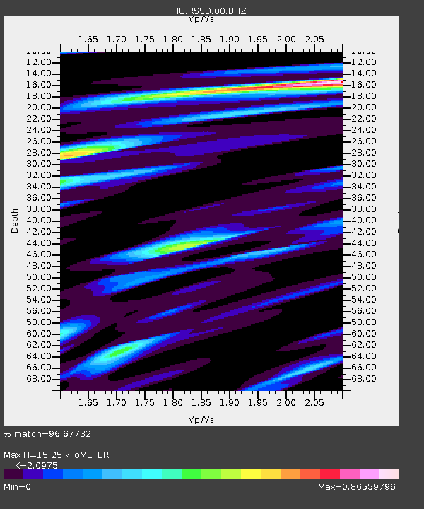
| Estimated Moho Depth: |
15.25 km |
| Estimated Crust Vp/Vs: |
2.10 |
| Assumed Crust Vp: |
6.242 km/s |
| Estimated Crust Vs: |
2.976 km/s |
| Estimated Crust Poisson's Ratio: |
0.35 |
|
| Radial Match: |
96.67732 % |
| Radial Bump: |
296 |
| Transverse Match: |
91.86591 % |
| Transverse Bump: |
400 |
| SOD ConfigId: |
2028011 |
| Insert Time: |
2017-04-12 04:15:01.114 +0000 |
| GWidth: |
2.5 |
| Max Bumps: |
400 |
| Tol: |
0.001 |
|
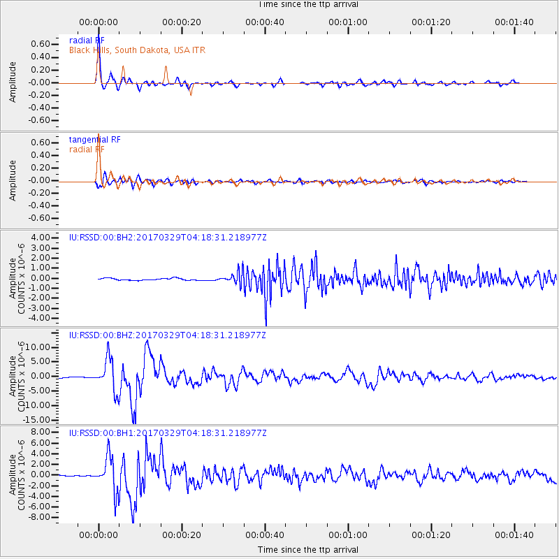
Signal To Noise
| Channel | StoN | STA | LTA |
| IU:RSSD:00:BHZ:20170329T04:18:31.218977Z | 25.614845 | 5.839088E-6 | 2.2795719E-7 |
| IU:RSSD:00:BH1:20170329T04:18:31.218977Z | 20.629135 | 3.3832282E-6 | 1.6400242E-7 |
| IU:RSSD:00:BH2:20170329T04:18:31.218977Z | 6.0598683 | 6.000952E-7 | 9.902776E-8 |
| Arrivals |
| Ps | 2.8 SECOND |
| PpPs | 7.3 SECOND |
| PsPs/PpSs | 10 SECOND |


