You are here: Home > Network List > TS - TERRAscope (Southern California Seismic Network) Stations List
> Station PAS Pasadena, California, USA > Earthquake Result Viewer
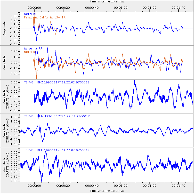
PAS Pasadena, California, USA - Earthquake Result Viewer
*The percent match for this event was below the threshold and hence no stack was calculated.
| Earthquake location: |
South Of Fiji Islands |
| Earthquake latitude/longitude: |
-22.2/-179.7 |
| Earthquake time(UTC): |
1996/11/17 (322) 21:11:20 GMT |
| Earthquake Depth: |
592 km |
| Earthquake Magnitude: |
5.5 MB, 6.1 UNKNOWN, 6.0 MW |
| Earthquake Catalog/Contributor: |
WHDF/NEIC |
|
| Network: |
TS TERRAscope (Southern California Seismic Network) |
| Station: |
PAS Pasadena, California, USA |
| Lat/Lon: |
34.15 N/118.17 W |
| Elevation: |
295 m |
|
| Distance: |
81.0 deg |
| Az: |
47.574 deg |
| Baz: |
235.577 deg |
| Ray Param: |
$rayparam |
*The percent match for this event was below the threshold and hence was not used in the summary stack. |
|
| Radial Match: |
64.66048 % |
| Radial Bump: |
400 |
| Transverse Match: |
69.40012 % |
| Transverse Bump: |
400 |
| SOD ConfigId: |
4480 |
| Insert Time: |
2010-02-26 14:37:40.876 +0000 |
| GWidth: |
2.5 |
| Max Bumps: |
400 |
| Tol: |
0.001 |
|
Signal To Noise
| Channel | StoN | STA | LTA |
| TS:PAS: :BHN:19961117T21:22:02.976001Z | 4.5130405 | 6.055539E-7 | 1.341787E-7 |
| TS:PAS: :BHE:19961117T21:22:02.976001Z | 2.0884497 | 3.20641E-7 | 1.5353062E-7 |
| TS:PAS: :BHZ:19961117T21:22:02.976001Z | 1.0514721 | 1.7286003E-7 | 1.6439813E-7 |
| Arrivals |
| Ps | |
| PpPs | |
| PsPs/PpSs | |


