You are here: Home > Network List > TA - USArray Transportable Network (new EarthScope stations) Stations List
> Station N31A Bailey Ranch, Gibbon, NE, USA > Earthquake Result Viewer
N31A Bailey Ranch, Gibbon, NE, USA - Earthquake Result Viewer
| Earthquake location: |
Samoa Islands Region |
| Earthquake latitude/longitude: |
-15.5/-172.1 |
| Earthquake time(UTC): |
2009/09/29 (272) 17:48:10 GMT |
| Earthquake Depth: |
18 km |
| Earthquake Magnitude: |
7.1 MB, 8.1 MS, 8.1 MW, 8.0 MW |
| Earthquake Catalog/Contributor: |
WHDF/NEIC |
|
| Network: |
TA USArray Transportable Network (new EarthScope stations) |
| Station: |
N31A Bailey Ranch, Gibbon, NE, USA |
| Lat/Lon: |
40.82 N/98.95 W |
| Elevation: |
687 m |
|
| Distance: |
87.7 deg |
| Az: |
46.622 deg |
| Baz: |
247.431 deg |
| Ray Param: |
0.043089204 |
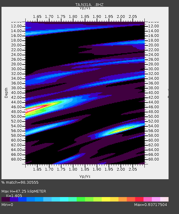
| Estimated Moho Depth: |
47.25 km |
| Estimated Crust Vp/Vs: |
1.61 |
| Assumed Crust Vp: |
6.53 km/s |
| Estimated Crust Vs: |
4.069 km/s |
| Estimated Crust Poisson's Ratio: |
0.18 |
|
| Radial Match: |
98.30555 % |
| Radial Bump: |
400 |
| Transverse Match: |
93.672554 % |
| Transverse Bump: |
400 |
| SOD ConfigId: |
2622 |
| Insert Time: |
2010-03-07 06:24:49.555 +0000 |
| GWidth: |
2.5 |
| Max Bumps: |
400 |
| Tol: |
0.001 |
|
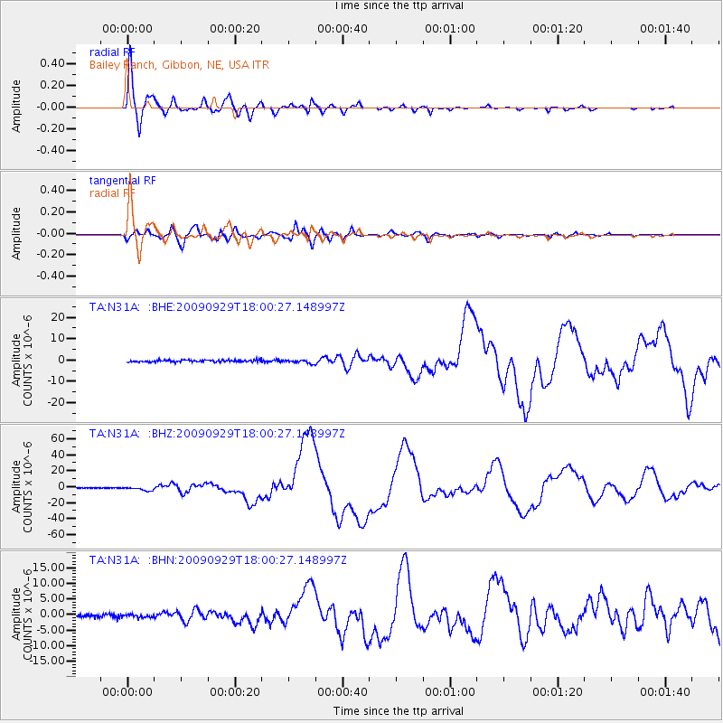
Signal To Noise
| Channel | StoN | STA | LTA |
| TA:N31A: :BHZ:20090929T18:00:27.148997Z | 7.825846 | 2.276179E-6 | 2.9085402E-7 |
| TA:N31A: :BHN:20090929T18:00:27.148997Z | 1.368446 | 5.4614503E-7 | 3.990987E-7 |
| TA:N31A: :BHE:20090929T18:00:27.148997Z | 1.8820446 | 8.3976244E-7 | 4.461969E-7 |
| Arrivals |
| Ps | 4.5 SECOND |
| PpPs | 18 SECOND |
| PsPs/PpSs | 23 SECOND |


