You are here: Home > Network List > TS - TERRAscope (Southern California Seismic Network) Stations List
> Station PAS Pasadena, California, USA > Earthquake Result Viewer
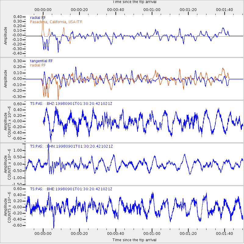
PAS Pasadena, California, USA - Earthquake Result Viewer
*The percent match for this event was below the threshold and hence no stack was calculated.
| Earthquake location: |
Tonga Islands |
| Earthquake latitude/longitude: |
-17.6/-174.8 |
| Earthquake time(UTC): |
1998/09/01 (244) 01:19:37 GMT |
| Earthquake Depth: |
220 km |
| Earthquake Magnitude: |
5.6 UNKNOWN, 5.3 MB, 5.6 MW |
| Earthquake Catalog/Contributor: |
WHDF/NEIC |
|
| Network: |
TS TERRAscope (Southern California Seismic Network) |
| Station: |
PAS Pasadena, California, USA |
| Lat/Lon: |
34.15 N/118.17 W |
| Elevation: |
295 m |
|
| Distance: |
74.5 deg |
| Az: |
45.944 deg |
| Baz: |
235.761 deg |
| Ray Param: |
$rayparam |
*The percent match for this event was below the threshold and hence was not used in the summary stack. |
|
| Radial Match: |
78.349396 % |
| Radial Bump: |
400 |
| Transverse Match: |
40.223835 % |
| Transverse Bump: |
400 |
| SOD ConfigId: |
4480 |
| Insert Time: |
2010-02-26 14:37:42.500 +0000 |
| GWidth: |
2.5 |
| Max Bumps: |
400 |
| Tol: |
0.001 |
|
Signal To Noise
| Channel | StoN | STA | LTA |
| TS:PAS: :BHN:19980901T01:30:20.421021Z | 2.2659397 | 4.2963168E-7 | 1.896042E-7 |
| TS:PAS: :BHE:19980901T01:30:20.421021Z | 0.86695415 | 1.7000563E-7 | 1.960953E-7 |
| TS:PAS: :BHZ:19980901T01:30:20.421021Z | 0.65363395 | 1.4966925E-7 | 2.2898021E-7 |
| Arrivals |
| Ps | |
| PpPs | |
| PsPs/PpSs | |


