You are here: Home > Network List > TA - USArray Transportable Network (new EarthScope stations) Stations List
> Station N31A Bailey Ranch, Gibbon, NE, USA > Earthquake Result Viewer
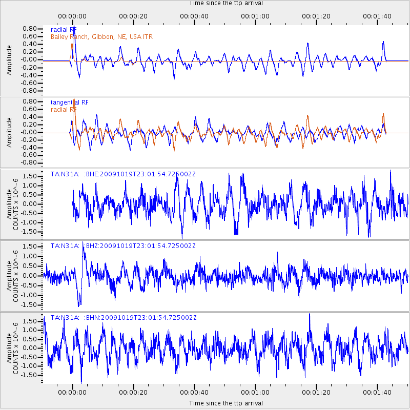
N31A Bailey Ranch, Gibbon, NE, USA - Earthquake Result Viewer
*The percent match for this event was below the threshold and hence no stack was calculated.
| Earthquake location: |
Samoa Islands Region |
| Earthquake latitude/longitude: |
-15.4/-172.3 |
| Earthquake time(UTC): |
2009/10/19 (292) 22:49:38 GMT |
| Earthquake Depth: |
18 km |
| Earthquake Magnitude: |
6.2 MB, 5.7 MS, 6.0 MW, 5.9 MW |
| Earthquake Catalog/Contributor: |
WHDF/NEIC |
|
| Network: |
TA USArray Transportable Network (new EarthScope stations) |
| Station: |
N31A Bailey Ranch, Gibbon, NE, USA |
| Lat/Lon: |
40.82 N/98.95 W |
| Elevation: |
687 m |
|
| Distance: |
87.8 deg |
| Az: |
46.675 deg |
| Baz: |
247.636 deg |
| Ray Param: |
$rayparam |
*The percent match for this event was below the threshold and hence was not used in the summary stack. |
|
| Radial Match: |
68.87085 % |
| Radial Bump: |
397 |
| Transverse Match: |
67.29319 % |
| Transverse Bump: |
400 |
| SOD ConfigId: |
2622 |
| Insert Time: |
2010-03-07 06:24:56.368 +0000 |
| GWidth: |
2.5 |
| Max Bumps: |
400 |
| Tol: |
0.001 |
|
Signal To Noise
| Channel | StoN | STA | LTA |
| TA:N31A: :BHZ:20091019T23:01:54.725002Z | 3.1719227 | 8.3679447E-7 | 2.63813E-7 |
| TA:N31A: :BHN:20091019T23:01:54.725002Z | 1.1537201 | 7.6132216E-7 | 6.5988456E-7 |
| TA:N31A: :BHE:20091019T23:01:54.725002Z | 1.5044574 | 7.167208E-7 | 4.7639824E-7 |
| Arrivals |
| Ps | |
| PpPs | |
| PsPs/PpSs | |


