You are here: Home > Network List > NE - New England Seismic Network Stations List
> Station BRYW Smithfield, RI, USA > Earthquake Result Viewer
BRYW Smithfield, RI, USA - Earthquake Result Viewer
| Earthquake location: |
Near East Coast Of Kamchatka |
| Earthquake latitude/longitude: |
56.9/162.7 |
| Earthquake time(UTC): |
2017/03/29 (088) 04:09:24 GMT |
| Earthquake Depth: |
23 km |
| Earthquake Magnitude: |
6.6 Mww |
| Earthquake Catalog/Contributor: |
NEIC PDE/us |
|
| Network: |
NE New England Seismic Network |
| Station: |
BRYW Smithfield, RI, USA |
| Lat/Lon: |
41.92 N/71.54 W |
| Elevation: |
116 m |
|
| Distance: |
71.5 deg |
| Az: |
39.714 deg |
| Baz: |
332.0 deg |
| Ray Param: |
0.054271266 |
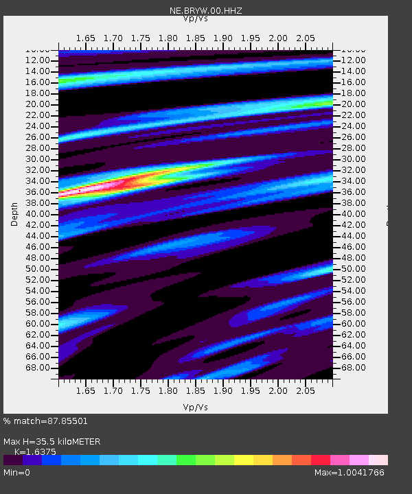
| Estimated Moho Depth: |
35.5 km |
| Estimated Crust Vp/Vs: |
1.64 |
| Assumed Crust Vp: |
6.472 km/s |
| Estimated Crust Vs: |
3.952 km/s |
| Estimated Crust Poisson's Ratio: |
0.20 |
|
| Radial Match: |
87.85501 % |
| Radial Bump: |
400 |
| Transverse Match: |
34.3696 % |
| Transverse Bump: |
400 |
| SOD ConfigId: |
2028011 |
| Insert Time: |
2017-04-12 04:16:07.031 +0000 |
| GWidth: |
2.5 |
| Max Bumps: |
400 |
| Tol: |
0.001 |
|

Signal To Noise
| Channel | StoN | STA | LTA |
| NE:BRYW:00:HHZ:20170329T04:20:12.384016Z | 9.9345255 | 3.4579714E-6 | 3.4807613E-7 |
| NE:BRYW:00:HH1:20170329T04:20:12.384016Z | 5.0615525 | 1.390609E-6 | 2.7473962E-7 |
| NE:BRYW:00:HH2:20170329T04:20:12.384016Z | 2.9518533 | 8.3025816E-7 | 2.8126672E-7 |
| Arrivals |
| Ps | 3.6 SECOND |
| PpPs | 14 SECOND |
| PsPs/PpSs | 18 SECOND |


