You are here: Home > Network List > TA - USArray Transportable Network (new EarthScope stations) Stations List
> Station G29A Hoven, SD, USA > Earthquake Result Viewer
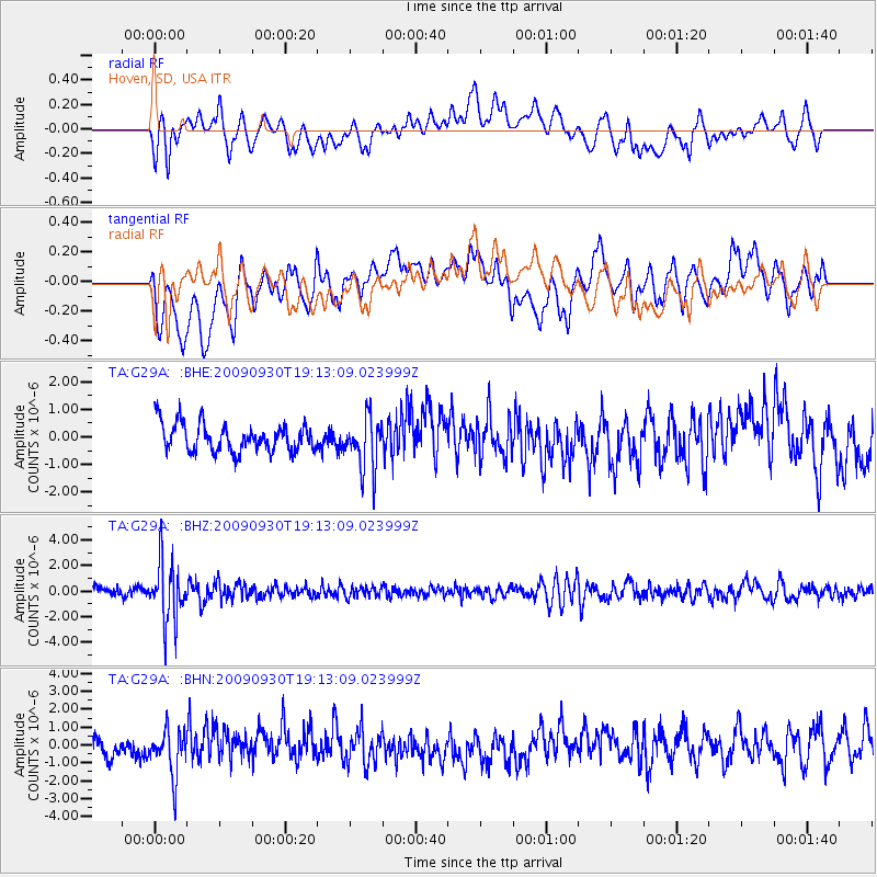
G29A Hoven, SD, USA - Earthquake Result Viewer
*The percent match for this event was below the threshold and hence no stack was calculated.
| Earthquake location: |
Peru-Bolivia Border Region |
| Earthquake latitude/longitude: |
-15.6/-69.3 |
| Earthquake time(UTC): |
2009/09/30 (273) 19:03:17 GMT |
| Earthquake Depth: |
255 km |
| Earthquake Magnitude: |
5.9 MB, 5.8 MW |
| Earthquake Catalog/Contributor: |
WHDF/NEIC |
|
| Network: |
TA USArray Transportable Network (new EarthScope stations) |
| Station: |
G29A Hoven, SD, USA |
| Lat/Lon: |
45.19 N/99.92 W |
| Elevation: |
588 m |
|
| Distance: |
66.5 deg |
| Az: |
336.876 deg |
| Baz: |
147.634 deg |
| Ray Param: |
$rayparam |
*The percent match for this event was below the threshold and hence was not used in the summary stack. |
|
| Radial Match: |
56.505882 % |
| Radial Bump: |
400 |
| Transverse Match: |
41.474567 % |
| Transverse Bump: |
400 |
| SOD ConfigId: |
2622 |
| Insert Time: |
2010-03-07 06:25:22.058 +0000 |
| GWidth: |
2.5 |
| Max Bumps: |
400 |
| Tol: |
0.001 |
|
Signal To Noise
| Channel | StoN | STA | LTA |
| TA:G29A: :BHZ:20090930T19:13:09.023999Z | 7.7239823 | 2.391468E-6 | 3.096159E-7 |
| TA:G29A: :BHN:20090930T19:13:09.023999Z | 1.6749201 | 1.2947929E-6 | 7.730476E-7 |
| TA:G29A: :BHE:20090930T19:13:09.023999Z | 1.8294449 | 9.301433E-7 | 5.0842925E-7 |
| Arrivals |
| Ps | |
| PpPs | |
| PsPs/PpSs | |


