You are here: Home > Network List > NM - Cooperative New Madrid Seismic Network Stations List
> Station HBAR Harrisburg,AR(CERI) > Earthquake Result Viewer
HBAR Harrisburg,AR(CERI) - Earthquake Result Viewer
| Earthquake location: |
Near East Coast Of Kamchatka |
| Earthquake latitude/longitude: |
56.9/162.7 |
| Earthquake time(UTC): |
2017/03/29 (088) 04:09:24 GMT |
| Earthquake Depth: |
23 km |
| Earthquake Magnitude: |
6.6 Mww |
| Earthquake Catalog/Contributor: |
NEIC PDE/us |
|
| Network: |
NM Cooperative New Madrid Seismic Network |
| Station: |
HBAR Harrisburg,AR(CERI) |
| Lat/Lon: |
35.56 N/90.66 W |
| Elevation: |
74 m |
|
| Distance: |
69.1 deg |
| Az: |
56.747 deg |
| Baz: |
325.778 deg |
| Ray Param: |
0.055825643 |
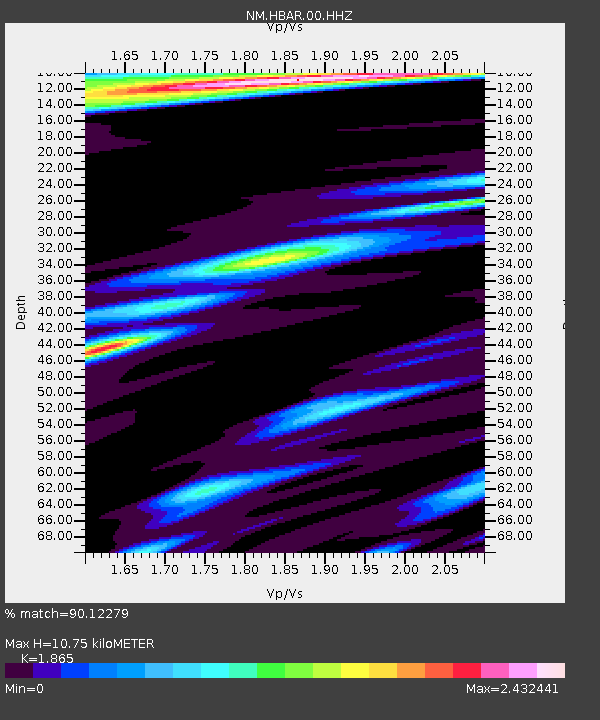
| Estimated Moho Depth: |
10.75 km |
| Estimated Crust Vp/Vs: |
1.87 |
| Assumed Crust Vp: |
6.273 km/s |
| Estimated Crust Vs: |
3.364 km/s |
| Estimated Crust Poisson's Ratio: |
0.30 |
|
| Radial Match: |
90.12279 % |
| Radial Bump: |
400 |
| Transverse Match: |
73.13893 % |
| Transverse Bump: |
400 |
| SOD ConfigId: |
2028011 |
| Insert Time: |
2017-04-12 04:16:34.622 +0000 |
| GWidth: |
2.5 |
| Max Bumps: |
400 |
| Tol: |
0.001 |
|

Signal To Noise
| Channel | StoN | STA | LTA |
| NM:HBAR:00:HHZ:20170329T04:19:58.004988Z | 25.85585 | 7.9884485E-6 | 3.0896098E-7 |
| NM:HBAR:00:HHN:20170329T04:19:58.004988Z | 5.5402374 | 2.5628447E-6 | 4.625875E-7 |
| NM:HBAR:00:HHE:20170329T04:19:58.004988Z | 6.6974225 | 2.9977436E-6 | 4.4759662E-7 |
| Arrivals |
| Ps | 1.5 SECOND |
| PpPs | 4.7 SECOND |
| PsPs/PpSs | 6.3 SECOND |


