You are here: Home > Network List > TA - USArray Transportable Network (new EarthScope stations) Stations List
> Station G30A Faulkton, SD, USA > Earthquake Result Viewer
G30A Faulkton, SD, USA - Earthquake Result Viewer
| Earthquake location: |
South Of Panama |
| Earthquake latitude/longitude: |
6.7/-82.6 |
| Earthquake time(UTC): |
2009/10/22 (295) 00:51:39 GMT |
| Earthquake Depth: |
18 km |
| Earthquake Magnitude: |
5.5 MB, 5.4 MS, 5.9 MW, 5.9 MW |
| Earthquake Catalog/Contributor: |
WHDF/NEIC |
|
| Network: |
TA USArray Transportable Network (new EarthScope stations) |
| Station: |
G30A Faulkton, SD, USA |
| Lat/Lon: |
45.13 N/99.14 W |
| Elevation: |
496 m |
|
| Distance: |
40.9 deg |
| Az: |
342.038 deg |
| Baz: |
154.361 deg |
| Ray Param: |
0.07411913 |
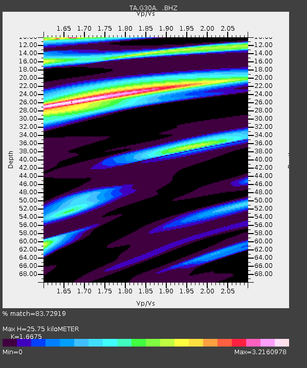
| Estimated Moho Depth: |
25.75 km |
| Estimated Crust Vp/Vs: |
1.67 |
| Assumed Crust Vp: |
6.53 km/s |
| Estimated Crust Vs: |
3.916 km/s |
| Estimated Crust Poisson's Ratio: |
0.22 |
|
| Radial Match: |
83.72919 % |
| Radial Bump: |
400 |
| Transverse Match: |
46.752758 % |
| Transverse Bump: |
400 |
| SOD ConfigId: |
2622 |
| Insert Time: |
2010-03-07 06:25:28.232 +0000 |
| GWidth: |
2.5 |
| Max Bumps: |
400 |
| Tol: |
0.001 |
|
Signal To Noise
| Channel | StoN | STA | LTA |
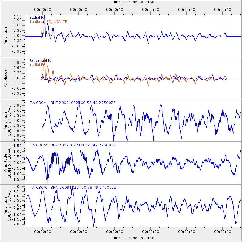
| TA:G30A: :BHZ:20091022T00:58:49.275002Z | 2.2291362 | 7.3433387E-7 | 3.294253E-7 |
| TA:G30A: :BHN:20091022T00:58:49.275002Z | 2.1755621 | 1.2200682E-6 | 5.608059E-7 |
| TA:G30A: :BHE:20091022T00:58:49.275002Z | 0.87577724 | 4.173045E-7 | 4.7649615E-7 |
| Arrivals |
| Ps | 2.8 SECOND |
| PpPs | 9.7 SECOND |
| PsPs/PpSs | 13 SECOND |


