You are here: Home > Network List > TA - USArray Transportable Network (new EarthScope stations) Stations List
> Station G30A Faulkton, SD, USA > Earthquake Result Viewer
G30A Faulkton, SD, USA - Earthquake Result Viewer
| Earthquake location: |
Ryukyu Islands, Japan |
| Earthquake latitude/longitude: |
29.2/129.8 |
| Earthquake time(UTC): |
2009/10/30 (303) 07:03:39 GMT |
| Earthquake Depth: |
34 km |
| Earthquake Magnitude: |
6.3 MB, 6.8 MS, 6.8 MW, 6.8 MW |
| Earthquake Catalog/Contributor: |
WHDF/NEIC |
|
| Network: |
TA USArray Transportable Network (new EarthScope stations) |
| Station: |
G30A Faulkton, SD, USA |
| Lat/Lon: |
45.13 N/99.14 W |
| Elevation: |
496 m |
|
| Distance: |
93.6 deg |
| Az: |
32.326 deg |
| Baz: |
318.674 deg |
| Ray Param: |
0.041208677 |
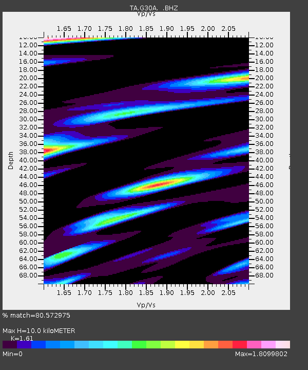
| Estimated Moho Depth: |
10.0 km |
| Estimated Crust Vp/Vs: |
1.61 |
| Assumed Crust Vp: |
6.53 km/s |
| Estimated Crust Vs: |
4.056 km/s |
| Estimated Crust Poisson's Ratio: |
0.19 |
|
| Radial Match: |
80.572975 % |
| Radial Bump: |
400 |
| Transverse Match: |
65.097626 % |
| Transverse Bump: |
400 |
| SOD ConfigId: |
2622 |
| Insert Time: |
2010-03-07 06:25:30.208 +0000 |
| GWidth: |
2.5 |
| Max Bumps: |
400 |
| Tol: |
0.001 |
|

Signal To Noise
| Channel | StoN | STA | LTA |
| TA:G30A: :BHZ:20091030T07:16:20.650029Z | 6.780652 | 1.5793565E-6 | 2.3292104E-7 |
| TA:G30A: :BHN:20091030T07:16:20.650029Z | 1.9881635 | 7.5602026E-7 | 3.8026062E-7 |
| TA:G30A: :BHE:20091030T07:16:20.650029Z | 1.4916595 | 4.9633877E-7 | 3.3274267E-7 |
| Arrivals |
| Ps | 1.0 SECOND |
| PpPs | 3.9 SECOND |
| PsPs/PpSs | 4.9 SECOND |


