You are here: Home > Network List > NM - Cooperative New Madrid Seismic Network Stations List
> Station PENM Penman,Portageville,MO > Earthquake Result Viewer
PENM Penman,Portageville,MO - Earthquake Result Viewer
| Earthquake location: |
Near East Coast Of Kamchatka |
| Earthquake latitude/longitude: |
56.9/162.7 |
| Earthquake time(UTC): |
2017/03/29 (088) 04:09:24 GMT |
| Earthquake Depth: |
23 km |
| Earthquake Magnitude: |
6.6 Mww |
| Earthquake Catalog/Contributor: |
NEIC PDE/us |
|
| Network: |
NM Cooperative New Madrid Seismic Network |
| Station: |
PENM Penman,Portageville,MO |
| Lat/Lon: |
36.45 N/89.63 W |
| Elevation: |
85 m |
|
| Distance: |
68.9 deg |
| Az: |
55.47 deg |
| Baz: |
325.922 deg |
| Ray Param: |
0.05600267 |
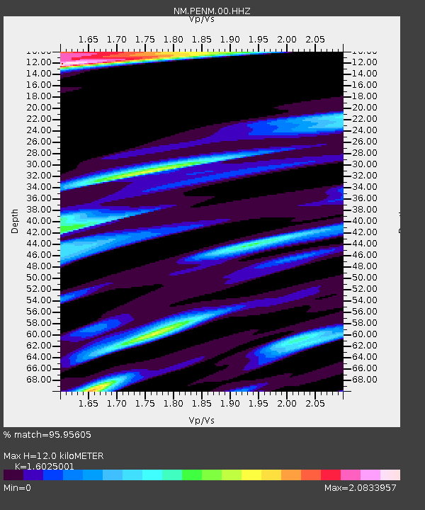
| Estimated Moho Depth: |
12.0 km |
| Estimated Crust Vp/Vs: |
1.60 |
| Assumed Crust Vp: |
6.444 km/s |
| Estimated Crust Vs: |
4.021 km/s |
| Estimated Crust Poisson's Ratio: |
0.18 |
|
| Radial Match: |
95.95605 % |
| Radial Bump: |
400 |
| Transverse Match: |
84.98135 % |
| Transverse Bump: |
400 |
| SOD ConfigId: |
2028011 |
| Insert Time: |
2017-04-12 04:16:45.365 +0000 |
| GWidth: |
2.5 |
| Max Bumps: |
400 |
| Tol: |
0.001 |
|

Signal To Noise
| Channel | StoN | STA | LTA |
| NM:PENM:00:HHZ:20170329T04:19:56.324995Z | 19.816486 | 8.130881E-6 | 4.103089E-7 |
| NM:PENM:00:HHN:20170329T04:19:56.324995Z | 8.799427 | 5.1638876E-6 | 5.868436E-7 |
| NM:PENM:00:HHE:20170329T04:19:56.324995Z | 5.8085623 | 3.4228253E-6 | 5.892724E-7 |
| Arrivals |
| Ps | 1.2 SECOND |
| PpPs | 4.6 SECOND |
| PsPs/PpSs | 5.8 SECOND |


