You are here: Home > Network List > TA - USArray Transportable Network (new EarthScope stations) Stations List
> Station G30A Faulkton, SD, USA > Earthquake Result Viewer
G30A Faulkton, SD, USA - Earthquake Result Viewer
| Earthquake location: |
Azores Islands Region |
| Earthquake latitude/longitude: |
36.2/-33.9 |
| Earthquake time(UTC): |
2009/11/04 (308) 18:41:44 GMT |
| Earthquake Depth: |
10 km |
| Earthquake Magnitude: |
5.7 MB, 5.6 MS, 5.9 MW, 5.8 MW |
| Earthquake Catalog/Contributor: |
WHDF/NEIC |
|
| Network: |
TA USArray Transportable Network (new EarthScope stations) |
| Station: |
G30A Faulkton, SD, USA |
| Lat/Lon: |
45.13 N/99.14 W |
| Elevation: |
496 m |
|
| Distance: |
49.1 deg |
| Az: |
301.738 deg |
| Baz: |
76.487 deg |
| Ray Param: |
0.06890941 |
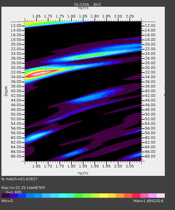
| Estimated Moho Depth: |
32.25 km |
| Estimated Crust Vp/Vs: |
1.66 |
| Assumed Crust Vp: |
6.53 km/s |
| Estimated Crust Vs: |
3.922 km/s |
| Estimated Crust Poisson's Ratio: |
0.22 |
|
| Radial Match: |
83.62927 % |
| Radial Bump: |
323 |
| Transverse Match: |
55.135414 % |
| Transverse Bump: |
392 |
| SOD ConfigId: |
2622 |
| Insert Time: |
2010-03-07 06:25:31.622 +0000 |
| GWidth: |
2.5 |
| Max Bumps: |
400 |
| Tol: |
0.001 |
|
Signal To Noise
| Channel | StoN | STA | LTA |
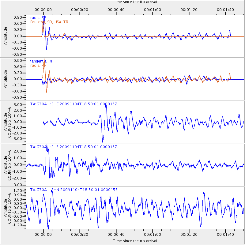
| TA:G30A: :BHZ:20091104T18:50:01.000015Z | 8.40137 | 1.5274019E-6 | 1.818039E-7 |
| TA:G30A: :BHN:20091104T18:50:01.000015Z | 1.6755759 | 8.170385E-7 | 4.8761655E-7 |
| TA:G30A: :BHE:20091104T18:50:01.000015Z | 6.062579 | 1.8176079E-6 | 2.9980768E-7 |
| Arrivals |
| Ps | 3.5 SECOND |
| PpPs | 12 SECOND |
| PsPs/PpSs | 16 SECOND |


