You are here: Home > Network List > NM - Cooperative New Madrid Seismic Network Stations List
> Station X502 Temporary Arkansas > Earthquake Result Viewer
X502 Temporary Arkansas - Earthquake Result Viewer
| Earthquake location: |
Near East Coast Of Kamchatka |
| Earthquake latitude/longitude: |
56.9/162.7 |
| Earthquake time(UTC): |
2017/03/29 (088) 04:09:24 GMT |
| Earthquake Depth: |
23 km |
| Earthquake Magnitude: |
6.6 Mww |
| Earthquake Catalog/Contributor: |
NEIC PDE/us |
|
| Network: |
NM Cooperative New Madrid Seismic Network |
| Station: |
X502 Temporary Arkansas |
| Lat/Lon: |
35.49 N/92.39 W |
| Elevation: |
344 m |
|
| Distance: |
68.4 deg |
| Az: |
58.034 deg |
| Baz: |
325.244 deg |
| Ray Param: |
0.05631333 |
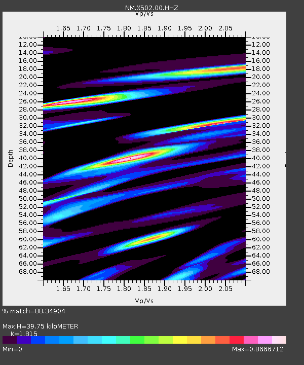
| Estimated Moho Depth: |
39.75 km |
| Estimated Crust Vp/Vs: |
1.82 |
| Assumed Crust Vp: |
6.498 km/s |
| Estimated Crust Vs: |
3.58 km/s |
| Estimated Crust Poisson's Ratio: |
0.28 |
|
| Radial Match: |
88.34904 % |
| Radial Bump: |
400 |
| Transverse Match: |
71.44262 % |
| Transverse Bump: |
400 |
| SOD ConfigId: |
2028011 |
| Insert Time: |
2017-04-12 04:16:52.683 +0000 |
| GWidth: |
2.5 |
| Max Bumps: |
400 |
| Tol: |
0.001 |
|

Signal To Noise
| Channel | StoN | STA | LTA |
| NM:X502:00:HHZ:20170329T04:19:53.379988Z | 16.607285 | 7.171734E-6 | 4.3184266E-7 |
| NM:X502:00:HHN:20170329T04:19:53.379988Z | 7.0369315 | 3.198367E-6 | 4.5451162E-7 |
| NM:X502:00:HHE:20170329T04:19:53.379988Z | 2.3161964 | 2.767507E-6 | 1.19485E-6 |
| Arrivals |
| Ps | 5.2 SECOND |
| PpPs | 17 SECOND |
| PsPs/PpSs | 22 SECOND |


