You are here: Home > Network List > US - United States National Seismic Network Stations List
> Station BW06 Boulder Array Site 6 (Pinedale), Wyoming, USA > Earthquake Result Viewer
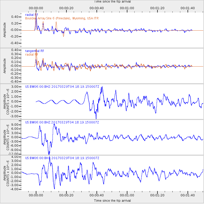
BW06 Boulder Array Site 6 (Pinedale), Wyoming, USA - Earthquake Result Viewer
| Earthquake location: |
Near East Coast Of Kamchatka |
| Earthquake latitude/longitude: |
56.9/162.7 |
| Earthquake time(UTC): |
2017/03/29 (088) 04:09:24 GMT |
| Earthquake Depth: |
23 km |
| Earthquake Magnitude: |
6.6 Mww |
| Earthquake Catalog/Contributor: |
NEIC PDE/us |
|
| Network: |
US United States National Seismic Network |
| Station: |
BW06 Boulder Array Site 6 (Pinedale), Wyoming, USA |
| Lat/Lon: |
42.77 N/109.56 W |
| Elevation: |
2224 m |
|
| Distance: |
54.4 deg |
| Az: |
64.791 deg |
| Baz: |
317.642 deg |
| Ray Param: |
0.06543149 |
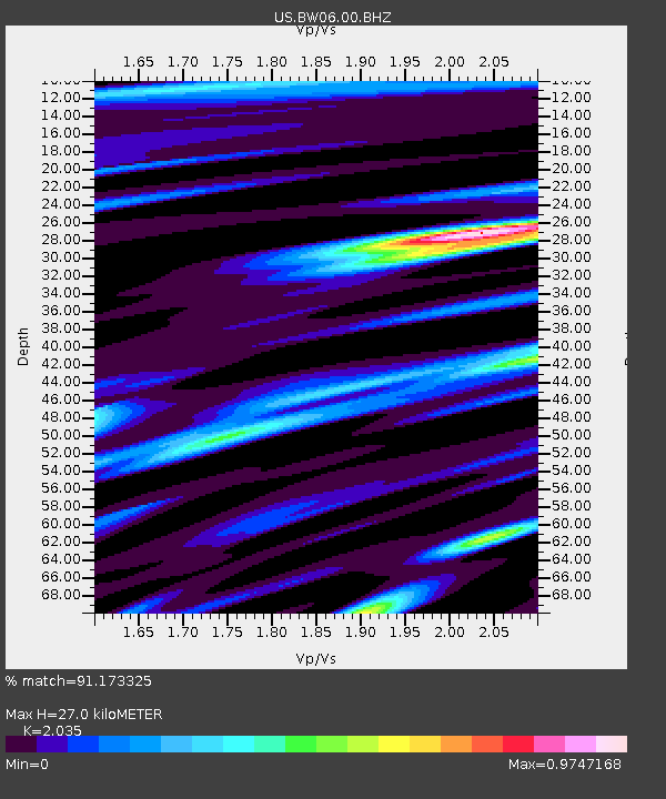
| Estimated Moho Depth: |
27.0 km |
| Estimated Crust Vp/Vs: |
2.04 |
| Assumed Crust Vp: |
6.161 km/s |
| Estimated Crust Vs: |
3.027 km/s |
| Estimated Crust Poisson's Ratio: |
0.34 |
|
| Radial Match: |
91.173325 % |
| Radial Bump: |
400 |
| Transverse Match: |
92.087425 % |
| Transverse Bump: |
400 |
| SOD ConfigId: |
2028011 |
| Insert Time: |
2017-04-12 04:17:36.288 +0000 |
| GWidth: |
2.5 |
| Max Bumps: |
400 |
| Tol: |
0.001 |
|
Signal To Noise
| Channel | StoN | STA | LTA |
| US:BW06:00:BHZ:20170329T04:18:19.150007Z | 12.760462 | 3.871241E-6 | 3.0337782E-7 |
| US:BW06:00:BH1:20170329T04:18:19.150007Z | 4.8575497 | 1.355729E-6 | 2.790973E-7 |
| US:BW06:00:BH2:20170329T04:18:19.150007Z | 4.147442 | 9.929735E-7 | 2.3941828E-7 |
| Arrivals |
| Ps | 4.7 SECOND |
| PpPs | 13 SECOND |
| PsPs/PpSs | 17 SECOND |


