You are here: Home > Network List > TA - USArray Transportable Network (new EarthScope stations) Stations List
> Station I30A Oacoma, SD, USA > Earthquake Result Viewer
I30A Oacoma, SD, USA - Earthquake Result Viewer
| Earthquake location: |
Samoa Islands Region |
| Earthquake latitude/longitude: |
-15.5/-172.1 |
| Earthquake time(UTC): |
2009/09/29 (272) 17:48:10 GMT |
| Earthquake Depth: |
18 km |
| Earthquake Magnitude: |
7.1 MB, 8.1 MS, 8.1 MW, 8.0 MW |
| Earthquake Catalog/Contributor: |
WHDF/NEIC |
|
| Network: |
TA USArray Transportable Network (new EarthScope stations) |
| Station: |
I30A Oacoma, SD, USA |
| Lat/Lon: |
43.91 N/99.43 W |
| Elevation: |
549 m |
|
| Distance: |
88.6 deg |
| Az: |
43.637 deg |
| Baz: |
247.019 deg |
| Ray Param: |
0.042439815 |
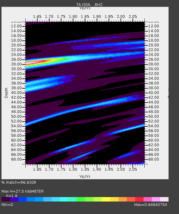
| Estimated Moho Depth: |
27.5 km |
| Estimated Crust Vp/Vs: |
1.60 |
| Assumed Crust Vp: |
6.53 km/s |
| Estimated Crust Vs: |
4.082 km/s |
| Estimated Crust Poisson's Ratio: |
0.18 |
|
| Radial Match: |
96.6309 % |
| Radial Bump: |
400 |
| Transverse Match: |
80.682365 % |
| Transverse Bump: |
400 |
| SOD ConfigId: |
2622 |
| Insert Time: |
2010-03-07 06:25:57.297 +0000 |
| GWidth: |
2.5 |
| Max Bumps: |
400 |
| Tol: |
0.001 |
|
Signal To Noise
| Channel | StoN | STA | LTA |
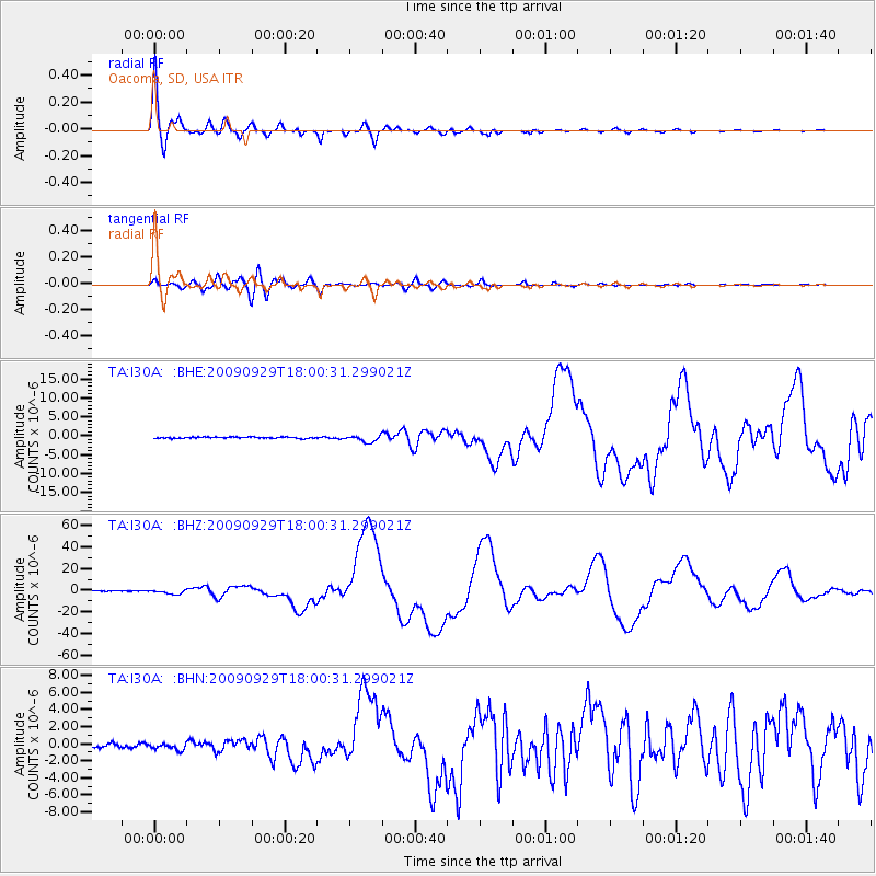
| TA:I30A: :BHZ:20090929T18:00:31.299021Z | 12.983211 | 1.991925E-6 | 1.5342314E-7 |
| TA:I30A: :BHN:20090929T18:00:31.299021Z | 1.524804 | 3.7285142E-7 | 2.4452416E-7 |
| TA:I30A: :BHE:20090929T18:00:31.299021Z | 5.1521263 | 9.1637406E-7 | 1.7786328E-7 |
| Arrivals |
| Ps | 2.6 SECOND |
| PpPs | 11 SECOND |
| PsPs/PpSs | 13 SECOND |


