You are here: Home > Network List > TA - USArray Transportable Network (new EarthScope stations) Stations List
> Station H16K Elim, AK, USA > Earthquake Result Viewer
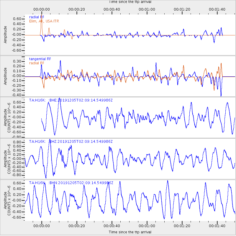
H16K Elim, AK, USA - Earthquake Result Viewer
*The percent match for this event was below the threshold and hence no stack was calculated.
| Earthquake location: |
Kuril Islands |
| Earthquake latitude/longitude: |
45.4/150.1 |
| Earthquake time(UTC): |
2019/12/05 (339) 02:03:18 GMT |
| Earthquake Depth: |
35 km |
| Earthquake Magnitude: |
5.6 Mww |
| Earthquake Catalog/Contributor: |
NEIC PDE/us |
|
| Network: |
TA USArray Transportable Network (new EarthScope stations) |
| Station: |
H16K Elim, AK, USA |
| Lat/Lon: |
64.64 N/162.24 W |
| Elevation: |
216 m |
|
| Distance: |
32.3 deg |
| Az: |
36.548 deg |
| Baz: |
256.825 deg |
| Ray Param: |
$rayparam |
*The percent match for this event was below the threshold and hence was not used in the summary stack. |
|
| Radial Match: |
50.632603 % |
| Radial Bump: |
400 |
| Transverse Match: |
53.055122 % |
| Transverse Bump: |
400 |
| SOD ConfigId: |
19951751 |
| Insert Time: |
2019-12-19 02:16:31.667 +0000 |
| GWidth: |
2.5 |
| Max Bumps: |
400 |
| Tol: |
0.001 |
|
Signal To Noise
| Channel | StoN | STA | LTA |
| TA:H16K: :BHZ:20191205T02:09:14.549986Z | 2.0643928 | 5.99499E-7 | 2.9039967E-7 |
| TA:H16K: :BHN:20191205T02:09:14.549986Z | 2.2347367 | 3.9573928E-7 | 1.7708541E-7 |
| TA:H16K: :BHE:20191205T02:09:14.549986Z | 0.6097907 | 2.1078414E-7 | 3.456664E-7 |
| Arrivals |
| Ps | |
| PpPs | |
| PsPs/PpSs | |


