You are here: Home > Network List > TA - USArray Transportable Network (new EarthScope stations) Stations List
> Station B18K Kokolik River, AK, USA > Earthquake Result Viewer
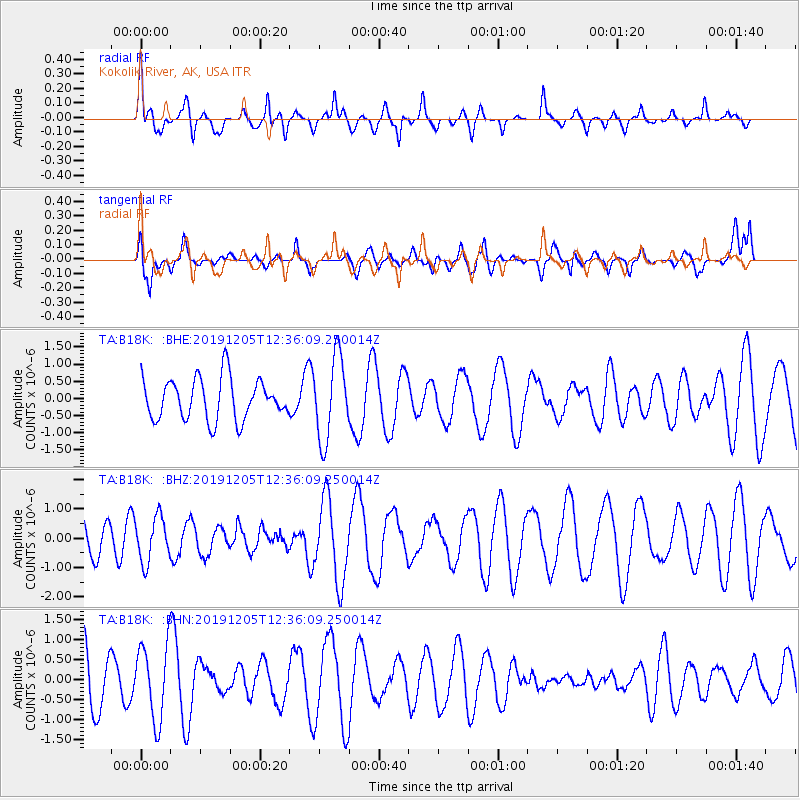
B18K Kokolik River, AK, USA - Earthquake Result Viewer
*The percent match for this event was below the threshold and hence no stack was calculated.
| Earthquake location: |
Mindanao, Philippines |
| Earthquake latitude/longitude: |
5.4/126.8 |
| Earthquake time(UTC): |
2019/12/05 (339) 12:24:45 GMT |
| Earthquake Depth: |
61 km |
| Earthquake Magnitude: |
5.5 Mww |
| Earthquake Catalog/Contributor: |
NEIC PDE/us |
|
| Network: |
TA USArray Transportable Network (new EarthScope stations) |
| Station: |
B18K Kokolik River, AK, USA |
| Lat/Lon: |
69.36 N/161.80 W |
| Elevation: |
222 m |
|
| Distance: |
78.5 deg |
| Az: |
20.055 deg |
| Baz: |
254.394 deg |
| Ray Param: |
$rayparam |
*The percent match for this event was below the threshold and hence was not used in the summary stack. |
|
| Radial Match: |
50.65283 % |
| Radial Bump: |
400 |
| Transverse Match: |
30.40767 % |
| Transverse Bump: |
400 |
| SOD ConfigId: |
19951751 |
| Insert Time: |
2019-12-19 12:36:09.085 +0000 |
| GWidth: |
2.5 |
| Max Bumps: |
400 |
| Tol: |
0.001 |
|
Signal To Noise
| Channel | StoN | STA | LTA |
| TA:B18K: :BHZ:20191205T12:36:09.250014Z | 0.9892869 | 7.603445E-7 | 7.6857833E-7 |
| TA:B18K: :BHN:20191205T12:36:09.250014Z | 1.425235 | 9.4208445E-7 | 6.6100284E-7 |
| TA:B18K: :BHE:20191205T12:36:09.250014Z | 2.0030556 | 1.2019823E-6 | 6.000743E-7 |
| Arrivals |
| Ps | |
| PpPs | |
| PsPs/PpSs | |


