You are here: Home > Network List > TA - USArray Transportable Network (new EarthScope stations) Stations List
> Station P32A Huiting Farm, Downs, KS, USA > Earthquake Result Viewer
P32A Huiting Farm, Downs, KS, USA - Earthquake Result Viewer
| Earthquake location: |
East Of Severnaya Zemlya |
| Earthquake latitude/longitude: |
81.6/119.5 |
| Earthquake time(UTC): |
2009/10/07 (280) 20:52:13 GMT |
| Earthquake Depth: |
8.0 km |
| Earthquake Magnitude: |
5.7 MB, 5.1 MS, 5.8 MW, 5.8 MW |
| Earthquake Catalog/Contributor: |
WHDF/NEIC |
|
| Network: |
TA USArray Transportable Network (new EarthScope stations) |
| Station: |
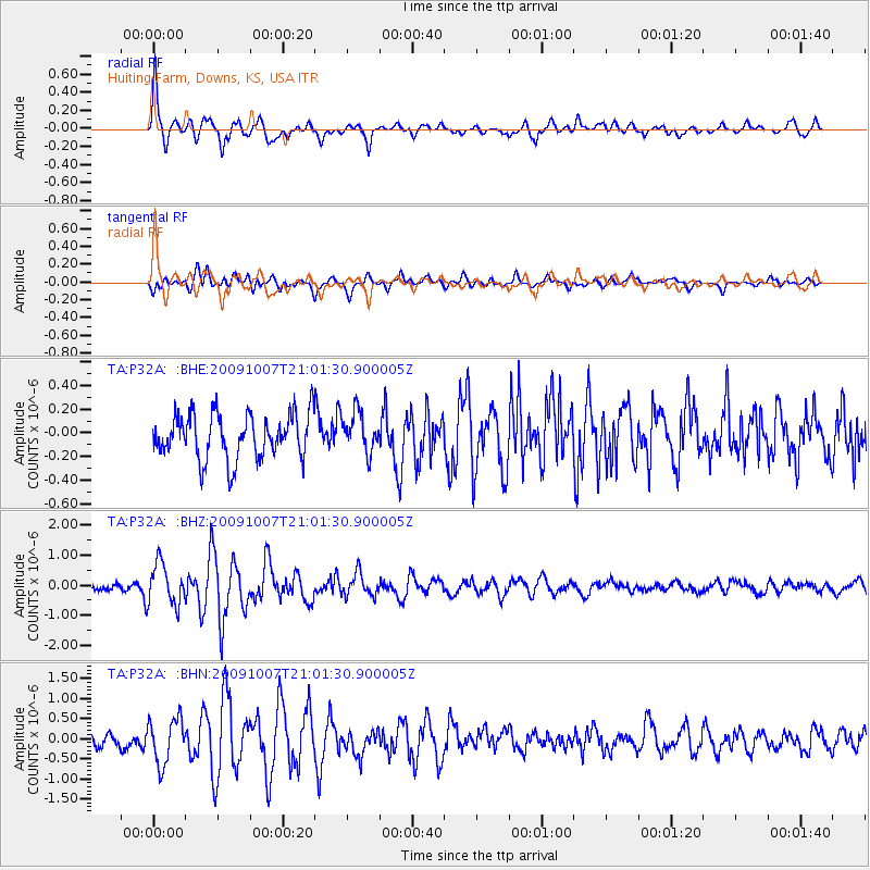
P32A Huiting Farm, Downs, KS, USA |
| Lat/Lon: |
39.62 N/98.60 W |
| Elevation: |
524 m |
|
| Distance: |
57.4 deg |
| Az: |
34.476 deg |
| Baz: |
353.793 deg |
| Ray Param: |
0.06351213 |
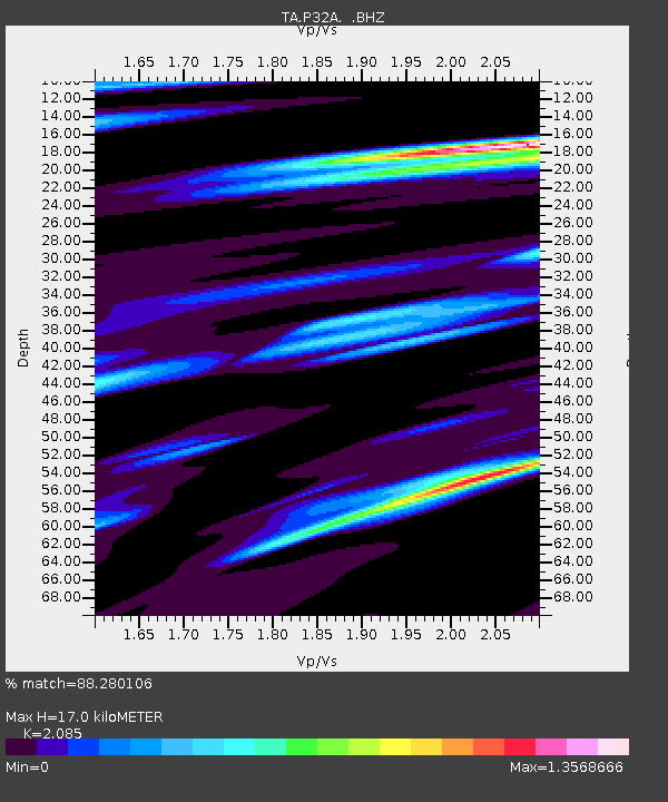
| Estimated Moho Depth: |
17.0 km |
| Estimated Crust Vp/Vs: |
2.09 |
| Assumed Crust Vp: |
6.483 km/s |
| Estimated Crust Vs: |
3.109 km/s |
| Estimated Crust Poisson's Ratio: |
0.35 |
|
| Radial Match: |
88.280106 % |
| Radial Bump: |
400 |
| Transverse Match: |
67.97825 % |
| Transverse Bump: |
400 |
| SOD ConfigId: |
2622 |
| Insert Time: |
2010-03-07 06:26:18.547 +0000 |
| GWidth: |
2.5 |
| Max Bumps: |
400 |
| Tol: |
0.001 |
|
Signal To Noise
| Channel | StoN | STA | LTA |
| TA:P32A: :BHZ:20091007T21:01:30.900005Z | 5.8455353 | 6.8574565E-7 | 1.1731101E-7 |
| TA:P32A: :BHN:20091007T21:01:30.900005Z | 2.7936988 | 5.631967E-7 | 2.0159537E-7 |
| TA:P32A: :BHE:20091007T21:01:30.900005Z | 0.9000901 | 1.6957E-7 | 1.8839226E-7 |
| Arrivals |
| Ps | 3.0 SECOND |
| PpPs | 7.7 SECOND |
| PsPs/PpSs | 11 SECOND |


