You are here: Home > Network List > US - United States National Seismic Network Stations List
> Station OGNE Ogallala, Nebraska, USA > Earthquake Result Viewer
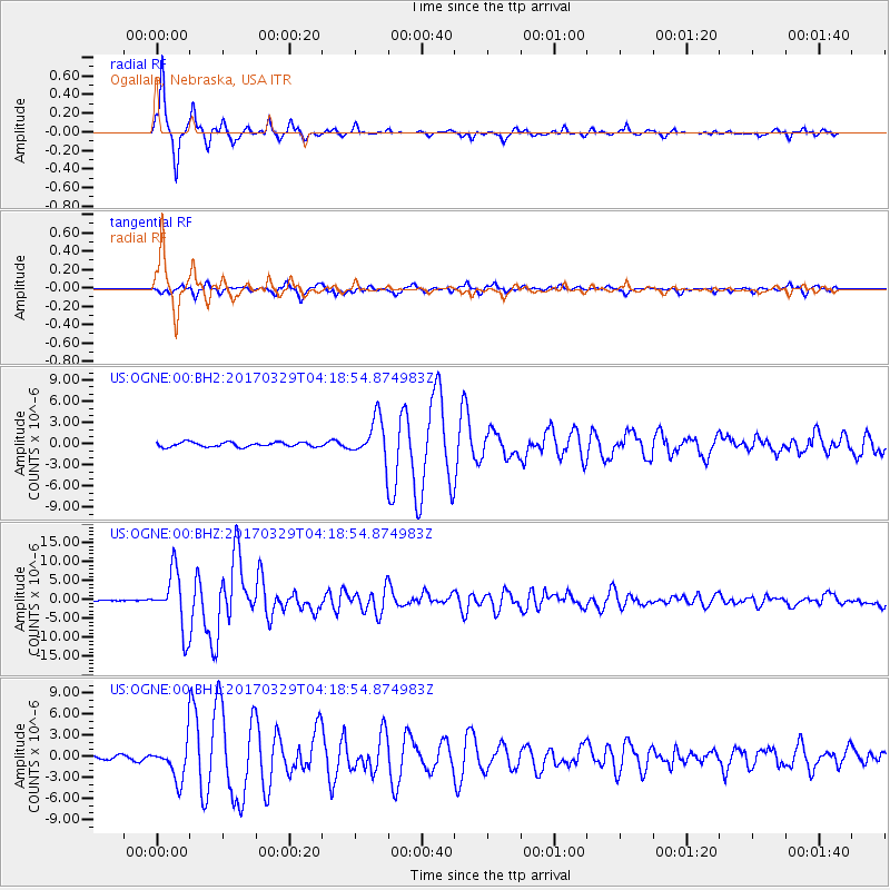
OGNE Ogallala, Nebraska, USA - Earthquake Result Viewer

| Earthquake location: |
Near East Coast Of Kamchatka |
| Earthquake latitude/longitude: |
56.9/162.7 |
| Earthquake time(UTC): |
2017/03/29 (088) 04:09:24 GMT |
| Earthquake Depth: |
23 km |
| Earthquake Magnitude: |
6.6 Mww |
| Earthquake Catalog/Contributor: |
NEIC PDE/us |
|
| Network: |
US United States National Seismic Network |
| Station: |
OGNE Ogallala, Nebraska, USA |
| Lat/Lon: |
40.95 N/102.03 W |
| Elevation: |
1054 m |
|
| Distance: |
59.5 deg |
| Az: |
61.138 deg |
| Baz: |
320.654 deg |
| Ray Param: |
0.062138114 |
| Estimated Moho Depth: |
40.5 km |
| Estimated Crust Vp/Vs: |
1.85 |
| Assumed Crust Vp: |
6.483 km/s |
| Estimated Crust Vs: |
3.509 km/s |
| Estimated Crust Poisson's Ratio: |
0.29 |
|
| Radial Match: |
98.04136 % |
| Radial Bump: |
237 |
| Transverse Match: |
88.871254 % |
| Transverse Bump: |
342 |
| SOD ConfigId: |
2028011 |
| Insert Time: |
2017-04-12 04:18:40.187 +0000 |
| GWidth: |
2.5 |
| Max Bumps: |
400 |
| Tol: |
0.001 |
|
Signal To Noise
| Channel | StoN | STA | LTA |
| US:OGNE:00:BHZ:20170329T04:18:54.874983Z | 62.05631 | 7.5752077E-6 | 1.220699E-7 |
| US:OGNE:00:BH1:20170329T04:18:54.874983Z | 7.454132 | 2.5754143E-6 | 3.4550158E-7 |
| US:OGNE:00:BH2:20170329T04:18:54.874983Z | 8.507242 | 2.779235E-6 | 3.2669047E-7 |
| Arrivals |
| Ps | 5.5 SECOND |
| PpPs | 17 SECOND |
| PsPs/PpSs | 23 SECOND |


