You are here: Home > Network List > US - United States National Seismic Network Stations List
> Station TPNV Topopah Spring, Nevada, USA > Earthquake Result Viewer
TPNV Topopah Spring, Nevada, USA - Earthquake Result Viewer

| Earthquake location: |
Near East Coast Of Kamchatka |
| Earthquake latitude/longitude: |
56.9/162.7 |
| Earthquake time(UTC): |
2017/03/29 (088) 04:09:24 GMT |
| Earthquake Depth: |
23 km |
| Earthquake Magnitude: |
6.6 Mww |
| Earthquake Catalog/Contributor: |
NEIC PDE/us |
|
| Network: |
US United States National Seismic Network |
| Station: |
TPNV Topopah Spring, Nevada, USA |
| Lat/Lon: |
36.95 N/116.25 W |
| Elevation: |
1600 m |
|
| Distance: |
55.3 deg |
| Az: |
74.22 deg |
| Baz: |
318.797 deg |
| Ray Param: |
0.06484331 |
| Estimated Moho Depth: |
33.5 km |
| Estimated Crust Vp/Vs: |
1.93 |
| Assumed Crust Vp: |
6.279 km/s |
| Estimated Crust Vs: |
3.245 km/s |
| Estimated Crust Poisson's Ratio: |
0.32 |
|
| Radial Match: |
90.79593 % |
| Radial Bump: |
400 |
| Transverse Match: |
82.078186 % |
| Transverse Bump: |
400 |
| SOD ConfigId: |
2028011 |
| Insert Time: |
2017-04-12 04:18:50.790 +0000 |
| GWidth: |
2.5 |
| Max Bumps: |
400 |
| Tol: |
0.001 |
|
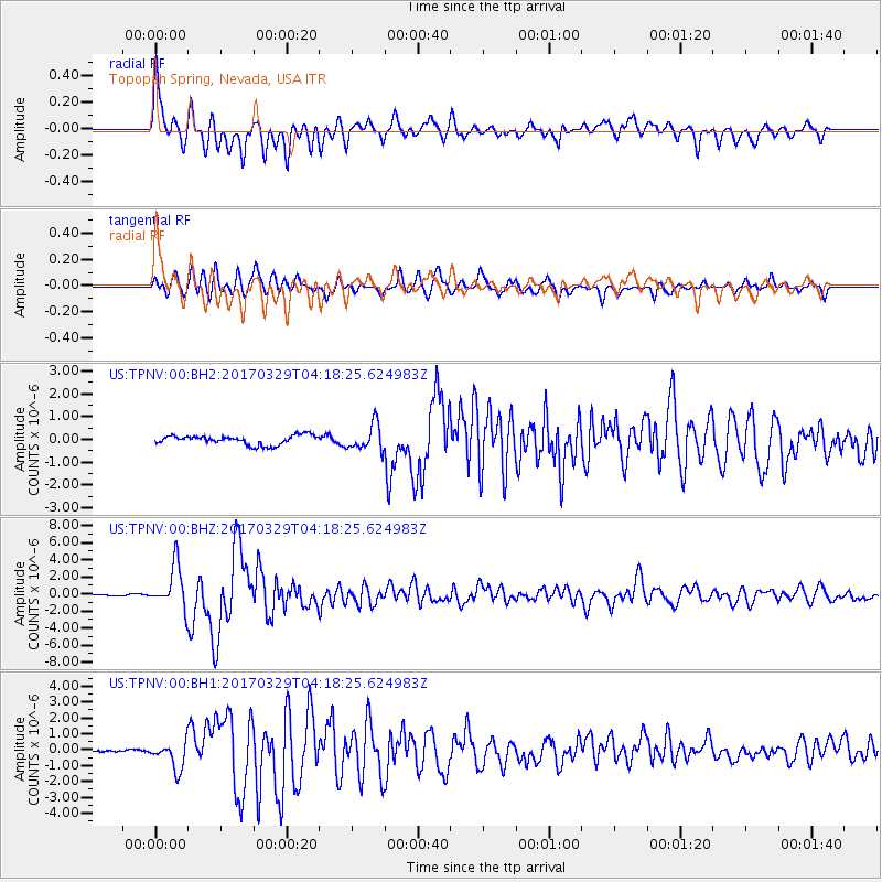
Signal To Noise
| Channel | StoN | STA | LTA |
| US:TPNV:00:BHZ:20170329T04:18:25.624983Z | 20.652239 | 2.4990409E-6 | 1.2100583E-7 |
| US:TPNV:00:BH1:20170329T04:18:25.624983Z | 4.081241 | 8.611075E-7 | 2.1099157E-7 |
| US:TPNV:00:BH2:20170329T04:18:25.624983Z | 2.8191953 | 5.725851E-7 | 2.0310233E-7 |
| Arrivals |
| Ps | 5.2 SECOND |
| PpPs | 15 SECOND |
| PsPs/PpSs | 20 SECOND |


