You are here: Home > Network List > GT - Global Telemetered Seismograph Network (USAF/USGS) Stations List
> Station LPAZ La Paz , Bolivia > Earthquake Result Viewer
LPAZ La Paz , Bolivia - Earthquake Result Viewer
| Earthquake location: |
Southwest Of Africa |
| Earthquake latitude/longitude: |
-52.8/11.4 |
| Earthquake time(UTC): |
2019/12/09 (343) 17:59:47 GMT |
| Earthquake Depth: |
10 km |
| Earthquake Magnitude: |
5.6 Mww |
| Earthquake Catalog/Contributor: |
NEIC PDE/us |
|
| Network: |
GT Global Telemetered Seismograph Network (USAF/USGS) |
| Station: |
LPAZ La Paz , Bolivia |
| Lat/Lon: |
16.17 S/68.08 W |
| Elevation: |
4817 m |
|
| Distance: |
71.0 deg |
| Az: |
268.264 deg |
| Baz: |
140.879 deg |
| Ray Param: |
0.054640967 |
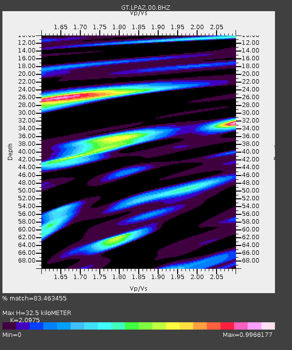
| Estimated Moho Depth: |
32.5 km |
| Estimated Crust Vp/Vs: |
2.10 |
| Assumed Crust Vp: |
6.454 km/s |
| Estimated Crust Vs: |
3.077 km/s |
| Estimated Crust Poisson's Ratio: |
0.35 |
|
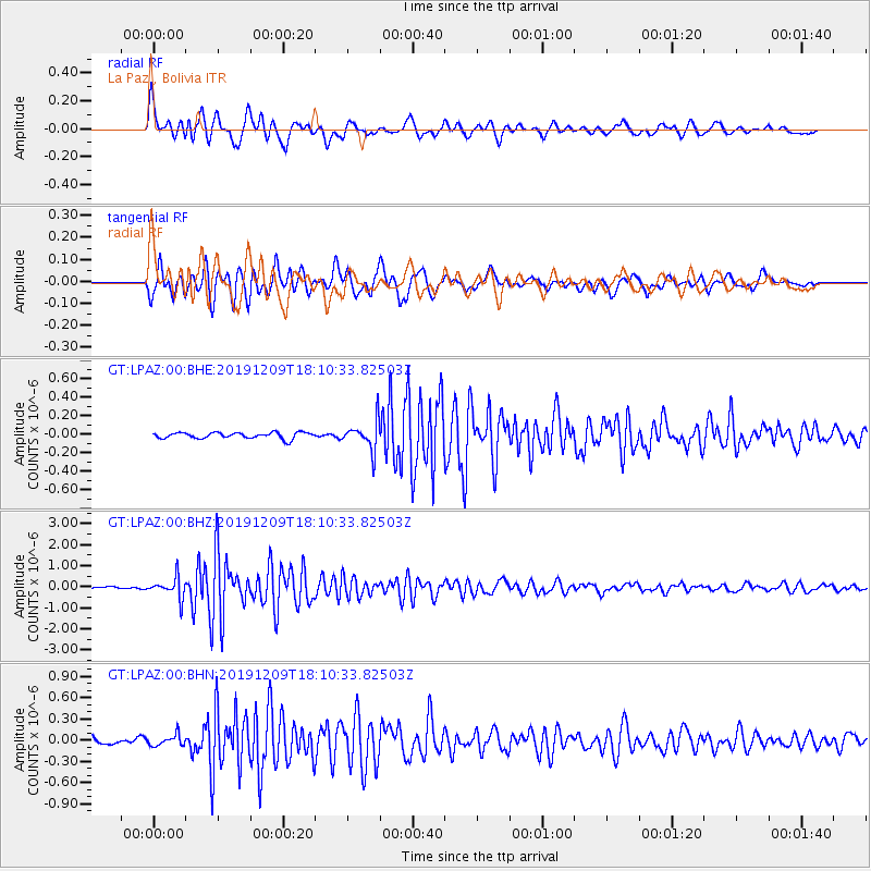
| Radial Match: |
83.463455 % |
| Radial Bump: |
400 |
| Transverse Match: |
76.36995 % |
| Transverse Bump: |
400 |
| SOD ConfigId: |
20358551 |
| Insert Time: |
2019-12-23 18:05:15.824 +0000 |
| GWidth: |
2.5 |
| Max Bumps: |
400 |
| Tol: |
0.001 |
|
Signal To Noise
| Channel | StoN | STA | LTA |
| GT:LPAZ:00:BHZ:20191209T18:10:33.82503Z | 6.4294744 | 4.774293E-7 | 7.425635E-8 |
| GT:LPAZ:00:BHN:20191209T18:10:33.82503Z | 1.7473596 | 7.691441E-8 | 4.4017504E-8 |
| GT:LPAZ:00:BHE:20191209T18:10:33.82503Z | 4.7117224 | 1.5445075E-7 | 3.2780104E-8 |
| Arrivals |
| Ps | 5.7 SECOND |
| PpPs | 15 SECOND |
| PsPs/PpSs | 21 SECOND |


