You are here: Home > Network List > TA - USArray Transportable Network (new EarthScope stations) Stations List
> Station D23K Nanushuk River, AK USA > Earthquake Result Viewer
D23K Nanushuk River, AK USA - Earthquake Result Viewer
*The percent match for this event was below the threshold and hence no stack was calculated.
| Earthquake location: |
Loyalty Islands |
| Earthquake latitude/longitude: |
-20.9/168.6 |
| Earthquake time(UTC): |
2019/12/10 (344) 08:40:42 GMT |
| Earthquake Depth: |
10 km |
| Earthquake Magnitude: |
5.6 Mww |
| Earthquake Catalog/Contributor: |
NEIC PDE/us |
|
| Network: |
TA USArray Transportable Network (new EarthScope stations) |
| Station: |
D23K Nanushuk River, AK USA |
| Lat/Lon: |
68.97 N/150.68 W |
| Elevation: |
406 m |
|
| Distance: |
94.3 deg |
| Az: |
13.671 deg |
| Baz: |
217.741 deg |
| Ray Param: |
$rayparam |
*The percent match for this event was below the threshold and hence was not used in the summary stack. |
|
| Radial Match: |
78.15493 % |
| Radial Bump: |
400 |
| Transverse Match: |
56.39134 % |
| Transverse Bump: |
400 |
| SOD ConfigId: |
20358551 |
| Insert Time: |
2019-12-24 08:52:56.989 +0000 |
| GWidth: |
2.5 |
| Max Bumps: |
400 |
| Tol: |
0.001 |
|
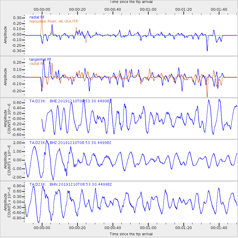
Signal To Noise
| Channel | StoN | STA | LTA |
| TA:D23K: :BHZ:20191210T08:53:30.44998Z | 1.3581676 | 1.5898239E-6 | 1.1705653E-6 |
| TA:D23K: :BHN:20191210T08:53:30.44998Z | 1.7671672 | 5.3372054E-7 | 3.020204E-7 |
| TA:D23K: :BHE:20191210T08:53:30.44998Z | 0.28906283 | 1.0005854E-7 | 3.4614808E-7 |
| Arrivals |
| Ps | |
| PpPs | |
| PsPs/PpSs | |


