You are here: Home > Network List > TA - USArray Transportable Network (new EarthScope stations) Stations List
> Station G03D McMinnville, OR, USA > Earthquake Result Viewer
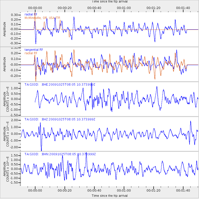
G03D McMinnville, OR, USA - Earthquake Result Viewer
*The percent match for this event was below the threshold and hence no stack was calculated.
| Earthquake location: |
South Of Fiji Islands |
| Earthquake latitude/longitude: |
-23.1/-179.2 |
| Earthquake time(UTC): |
2009/10/25 (298) 07:53:52 GMT |
| Earthquake Depth: |
418 km |
| Earthquake Magnitude: |
5.6 MB, 6.0 MW, 5.9 MW |
| Earthquake Catalog/Contributor: |
WHDF/NEIC |
|
| Network: |
TA USArray Transportable Network (new EarthScope stations) |
| Station: |
G03D McMinnville, OR, USA |
| Lat/Lon: |
45.21 N/123.26 W |
| Elevation: |
222 m |
|
| Distance: |
84.9 deg |
| Az: |
36.01 deg |
| Baz: |
229.986 deg |
| Ray Param: |
$rayparam |
*The percent match for this event was below the threshold and hence was not used in the summary stack. |
|
| Radial Match: |
48.125214 % |
| Radial Bump: |
400 |
| Transverse Match: |
46.299034 % |
| Transverse Bump: |
400 |
| SOD ConfigId: |
2622 |
| Insert Time: |
2010-03-07 06:27:19.759 +0000 |
| GWidth: |
2.5 |
| Max Bumps: |
400 |
| Tol: |
0.001 |
|
Signal To Noise
| Channel | StoN | STA | LTA |
| TA:G03D: :BHZ:20091025T08:05:10.373999Z | 2.9138365 | 8.8862413E-7 | 3.0496705E-7 |
| TA:G03D: :BHN:20091025T08:05:10.373999Z | 0.8264882 | 3.5111734E-7 | 4.248304E-7 |
| TA:G03D: :BHE:20091025T08:05:10.373999Z | 1.5319409 | 5.089681E-7 | 3.3223745E-7 |
| Arrivals |
| Ps | |
| PpPs | |
| PsPs/PpSs | |


