You are here: Home > Network List > TJ - Tajikistan National Seismic Network Stations List
> Station GARM Garm, Tajikistan > Earthquake Result Viewer
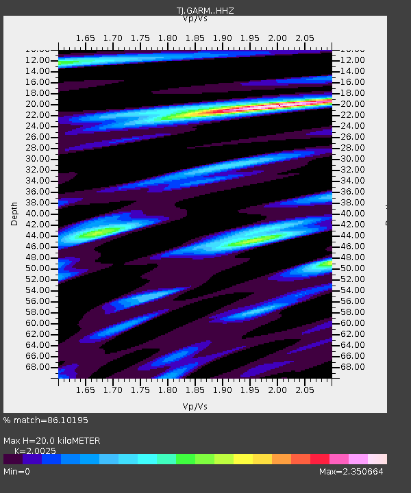
GARM Garm, Tajikistan - Earthquake Result Viewer
| Earthquake location: |
Southeast Of Honshu, Japan |
| Earthquake latitude/longitude: |
30.7/141.7 |
| Earthquake time(UTC): |
2019/12/10 (344) 17:05:02 GMT |
| Earthquake Depth: |
14 km |
| Earthquake Magnitude: |
5.9 Mww |
| Earthquake Catalog/Contributor: |
NEIC PDE/us |
|
| Network: |
TJ Tajikistan National Seismic Network |
| Station: |
GARM Garm, Tajikistan |
| Lat/Lon: |
39.00 N/70.32 E |
| Elevation: |
1305 m |
|
| Distance: |
57.8 deg |
| Az: |
299.247 deg |
| Baz: |
74.651 deg |
| Ray Param: |
0.0632282 |
| Estimated Moho Depth: |
20.0 km |
| Estimated Crust Vp/Vs: |
2.00 |
| Assumed Crust Vp: |
6.306 km/s |
| Estimated Crust Vs: |
3.149 km/s |
| Estimated Crust Poisson's Ratio: |
0.33 |
|
| Radial Match: |
86.10195 % |
| Radial Bump: |
369 |
| Transverse Match: |
78.53538 % |
| Transverse Bump: |
400 |
| SOD ConfigId: |
20358551 |
| Insert Time: |
2019-12-24 17:19:27.622 +0000 |
| GWidth: |
2.5 |
| Max Bumps: |
400 |
| Tol: |
0.001 |
|

Signal To Noise
| Channel | StoN | STA | LTA |
| TJ:GARM: :HHZ:20191210T17:14:22.479988Z | 12.7600765 | 3.4437055E-6 | 2.6988127E-7 |
| TJ:GARM: :HHN:20191210T17:14:22.479988Z | 1.2566016 | 4.5301684E-7 | 3.6050952E-7 |
| TJ:GARM: :HHE:20191210T17:14:22.479988Z | 8.168031 | 1.4589675E-6 | 1.7861925E-7 |
| Arrivals |
| Ps | 3.3 SECOND |
| PpPs | 9.1 SECOND |
| PsPs/PpSs | 12 SECOND |


