You are here: Home > Network List > TX - Texas Seismological Network Stations List
> Station FW11 UT at Arlington > Earthquake Result Viewer
FW11 UT at Arlington - Earthquake Result Viewer
| Earthquake location: |
Near East Coast Of Kamchatka |
| Earthquake latitude/longitude: |
56.9/162.7 |
| Earthquake time(UTC): |
2017/03/29 (088) 04:09:24 GMT |
| Earthquake Depth: |
23 km |
| Earthquake Magnitude: |
6.6 Mww |
| Earthquake Catalog/Contributor: |
NEIC PDE/us |
|
| Network: |
TX Texas Seismological Network |
| Station: |
FW11 UT at Arlington |
| Lat/Lon: |
32.72 N/97.13 W |
| Elevation: |
198 m |
|
| Distance: |
68.4 deg |
| Az: |
63.203 deg |
| Baz: |
324.501 deg |
| Ray Param: |
0.056318033 |
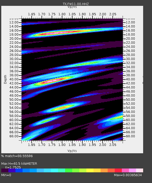
| Estimated Moho Depth: |
40.5 km |
| Estimated Crust Vp/Vs: |
1.75 |
| Assumed Crust Vp: |
6.38 km/s |
| Estimated Crust Vs: |
3.641 km/s |
| Estimated Crust Poisson's Ratio: |
0.26 |
|
| Radial Match: |
88.55596 % |
| Radial Bump: |
400 |
| Transverse Match: |
77.42521 % |
| Transverse Bump: |
400 |
| SOD ConfigId: |
2028011 |
| Insert Time: |
2017-04-12 04:20:44.657 +0000 |
| GWidth: |
2.5 |
| Max Bumps: |
400 |
| Tol: |
0.001 |
|
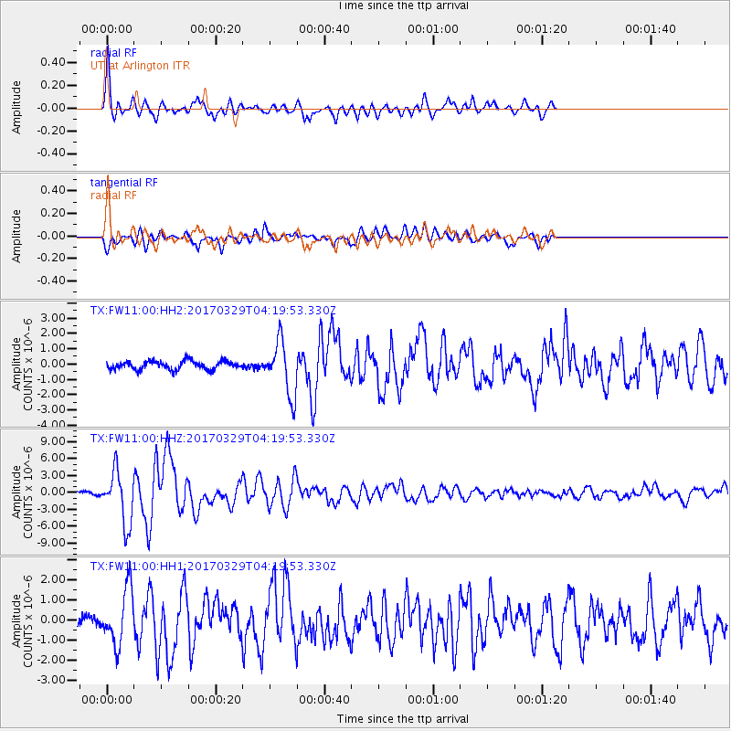
Signal To Noise
| Channel | StoN | STA | LTA |
| TX:FW11:00:HHZ:20170329T04:19:53.330Z | 25.189737 | 4.637478E-6 | 1.8410188E-7 |
| TX:FW11:00:HH1:20170329T04:19:53.330Z | 6.1067777 | 1.3838111E-6 | 2.266025E-7 |
| TX:FW11:00:HH2:20170329T04:19:53.330Z | 6.3090897 | 1.7635875E-6 | 2.7953124E-7 |
| Arrivals |
| Ps | 5.0 SECOND |
| PpPs | 17 SECOND |
| PsPs/PpSs | 22 SECOND |


