You are here: Home > Network List > CN - Canadian National Seismograph Network Stations List
> Station INK INUVIK, NT > Earthquake Result Viewer
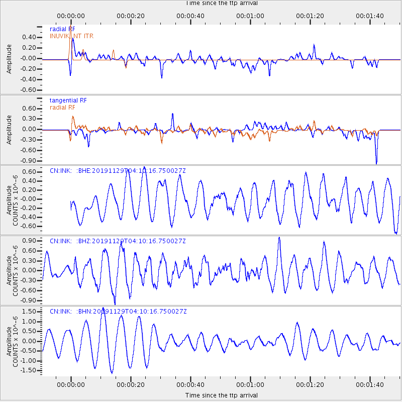
INK INUVIK, NT - Earthquake Result Viewer
*The percent match for this event was below the threshold and hence no stack was calculated.
| Earthquake location: |
Off East Coast Of Honshu, Japan |
| Earthquake latitude/longitude: |
39.2/143.0 |
| Earthquake time(UTC): |
2019/11/29 (333) 04:01:40 GMT |
| Earthquake Depth: |
19 km |
| Earthquake Magnitude: |
5.4 Mww |
| Earthquake Catalog/Contributor: |
NEIC PDE/us |
|
| Network: |
CN Canadian National Seismograph Network |
| Station: |
INK INUVIK, NT |
| Lat/Lon: |
68.31 N/133.53 W |
| Elevation: |
44 m |
|
| Distance: |
51.9 deg |
| Az: |
27.987 deg |
| Baz: |
281.106 deg |
| Ray Param: |
$rayparam |
*The percent match for this event was below the threshold and hence was not used in the summary stack. |
|
| Radial Match: |
63.010548 % |
| Radial Bump: |
400 |
| Transverse Match: |
58.088177 % |
| Transverse Bump: |
400 |
| SOD ConfigId: |
20358551 |
| Insert Time: |
2019-12-27 04:02:04.723 +0000 |
| GWidth: |
2.5 |
| Max Bumps: |
400 |
| Tol: |
0.001 |
|
Signal To Noise
| Channel | StoN | STA | LTA |
| CN:INK: :BHZ:20191129T04:10:16.750027Z | 0.45087913 | 2.4357004E-7 | 5.402114E-7 |
| CN:INK: :BHN:20191129T04:10:16.750027Z | 1.507453 | 6.325396E-7 | 4.1960817E-7 |
| CN:INK: :BHE:20191129T04:10:16.750027Z | 1.2033336 | 3.9333585E-7 | 3.2687183E-7 |
| Arrivals |
| Ps | |
| PpPs | |
| PsPs/PpSs | |


