You are here: Home > Network List > TX - Texas Seismological Network Stations List
> Station HNDO Hondo > Earthquake Result Viewer
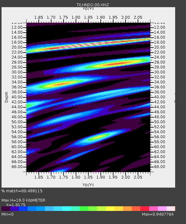
HNDO Hondo - Earthquake Result Viewer
| Earthquake location: |
Near East Coast Of Kamchatka |
| Earthquake latitude/longitude: |
56.9/162.7 |
| Earthquake time(UTC): |
2017/03/29 (088) 04:09:24 GMT |
| Earthquake Depth: |
23 km |
| Earthquake Magnitude: |
6.6 Mww |
| Earthquake Catalog/Contributor: |
NEIC PDE/us |
|
| Network: |
TX Texas Seismological Network |
| Station: |
HNDO Hondo |
| Lat/Lon: |
29.53 N/99.28 W |
| Elevation: |
381 m |
|
| Distance: |
69.9 deg |
| Az: |
66.787 deg |
| Baz: |
324.67 deg |
| Ray Param: |
0.055312913 |
| Estimated Moho Depth: |
19.0 km |
| Estimated Crust Vp/Vs: |
1.82 |
| Assumed Crust Vp: |
6.347 km/s |
| Estimated Crust Vs: |
3.492 km/s |
| Estimated Crust Poisson's Ratio: |
0.28 |
|
| Radial Match: |
88.499115 % |
| Radial Bump: |
400 |
| Transverse Match: |
71.76262 % |
| Transverse Bump: |
400 |
| SOD ConfigId: |
2028011 |
| Insert Time: |
2017-04-12 04:21:14.758 +0000 |
| GWidth: |
2.5 |
| Max Bumps: |
400 |
| Tol: |
0.001 |
|

Signal To Noise
| Channel | StoN | STA | LTA |
| TX:HNDO:00:HHZ:20170329T04:20:02.754988Z | 28.253077 | 3.2395747E-6 | 1.1466272E-7 |
| TX:HNDO:00:HH1:20170329T04:20:02.754988Z | 7.4905343 | 8.4208347E-7 | 1.1241968E-7 |
| TX:HNDO:00:HH2:20170329T04:20:02.754988Z | 9.337384 | 1.376479E-6 | 1.474159E-7 |
| Arrivals |
| Ps | 2.5 SECOND |
| PpPs | 8.1 SECOND |
| PsPs/PpSs | 11 SECOND |


