You are here: Home > Network List > MN - MEDNET Project Stations List
> Station AQU L'Aquila, Italy > Earthquake Result Viewer
AQU L'Aquila, Italy - Earthquake Result Viewer
| Earthquake location: |
Peru-Brazil Border Region |
| Earthquake latitude/longitude: |
-11.0/-70.8 |
| Earthquake time(UTC): |
1990/10/17 (290) 14:30:14 GMT |
| Earthquake Depth: |
624 km |
| Earthquake Magnitude: |
6.7 MB, 6.8 UNKNOWN |
| Earthquake Catalog/Contributor: |
WHDF/NEIC |
|
| Network: |
MN MEDNET Project |
| Station: |
AQU L'Aquila, Italy |
| Lat/Lon: |
42.35 N/13.40 E |
| Elevation: |
710 m |
|
| Distance: |
93.1 deg |
| Az: |
47.602 deg |
| Baz: |
258.025 deg |
| Ray Param: |
0.04077756 |
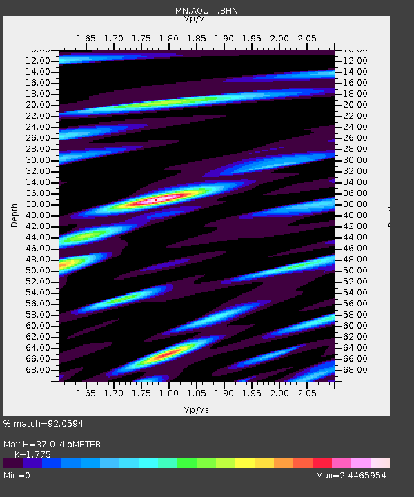
| Estimated Moho Depth: |
37.0 km |
| Estimated Crust Vp/Vs: |
1.77 |
| Assumed Crust Vp: |
6.276 km/s |
| Estimated Crust Vs: |
3.536 km/s |
| Estimated Crust Poisson's Ratio: |
0.27 |
|
| Radial Match: |
92.0594 % |
| Radial Bump: |
400 |
| Transverse Match: |
86.69232 % |
| Transverse Bump: |
400 |
| SOD ConfigId: |
16938 |
| Insert Time: |
2010-03-08 16:32:50.832 +0000 |
| GWidth: |
2.5 |
| Max Bumps: |
400 |
| Tol: |
0.001 |
|
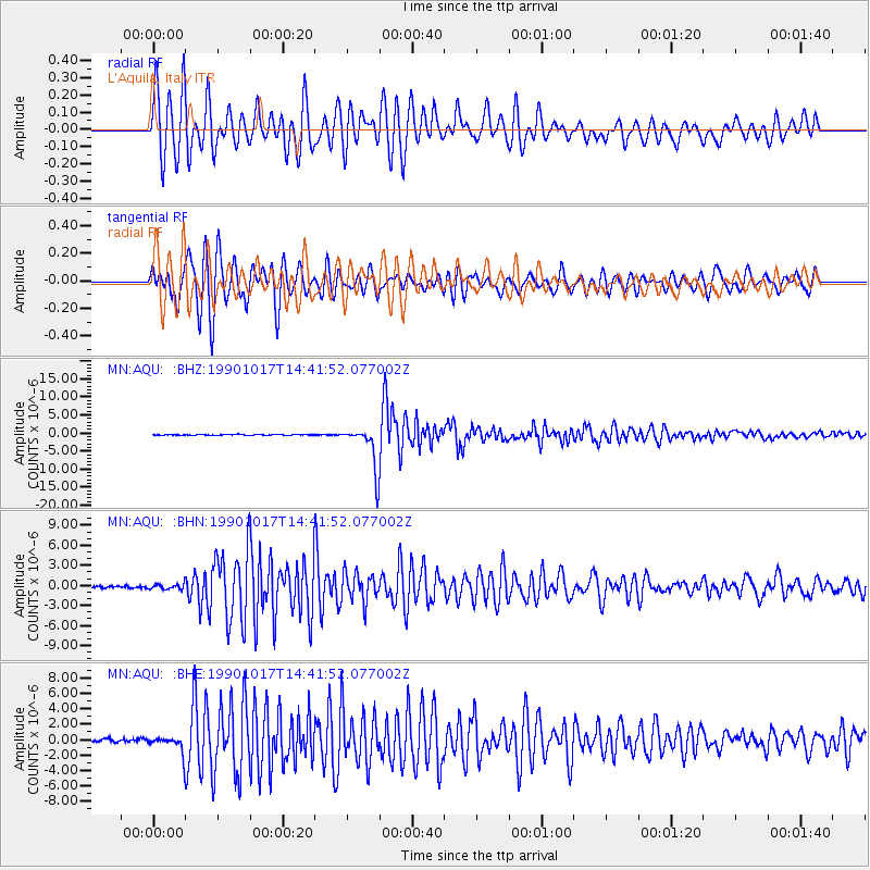
Signal To Noise
| Channel | StoN | STA | LTA |
| MN:AQU: :BHN:19901017T14:41:52.077002Z | 2.2772338 | 4.177007E-7 | 1.8342459E-7 |
| MN:AQU: :BHE:19901017T14:41:52.077002Z | 5.809098 | 1.1824034E-6 | 2.0354338E-7 |
| MN:AQU: :BHZ:19901017T14:41:52.077002Z | 53.012066 | 6.0209677E-6 | 1.1357731E-7 |
| Arrivals |
| Ps | 4.7 SECOND |
| PpPs | 16 SECOND |
| PsPs/PpSs | 21 SECOND |


